
Geographic Region: USA-ARIZONA
Feature: YUMA,COLORADO RIVER,AGR.
|
Geographic Region: USA-ARIZONA Feature: YUMA,COLORADO RIVER,AGR. |
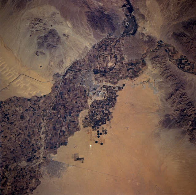 |
| STS073-702-071 Yuma Area, Arizona, U.S.A. October 1995 Some street patterns of Yuma are visible near the center of this near-vertical photograph. The northeast-southwest-oriented runway of Yuma International Airport can be seen immediately southeast of the city. Farther east, the Gila Mountains obstruct the Gila River, forcing it to detour to the north before it merges with the Colorado River on the outskirts of Yuma. The All American Canal, which carries water from the Colorado River to parts of the Imperial Valley in southern California, appears as a dark line that crosses the southern end of the Sand Hills. Cultivated field patterns cover the landscape where adequate irrigation water is available, and a few circular field patterns south of Yuma indicate the use of center-pivot irrigation. The Mexican desert town of San Luis is visible near the lower left edge of the photograph, and the U.S.-Mexico border can be traced eastward through the desert. |
| Images: | All Available Images Low-Resolution 333k |
|
| Mission: | STS073 |
|
| Roll - Frame: | 702 - 71 |
|
| Geographical Name: | USA-ARIZONA |
|
| Features: | YUMA,COLORADO RIVER,AGR. |
|
| Center Lat x Lon: | 32.5N x 114.5W |
|
| Film Exposure: | N | N=Normal exposure, U=Under exposed, O=Over exposed, F=out of Focus |
| Percentage of Cloud Cover-CLDP: | 0 |
|
| Camera:: | HB |
|
| Camera Tilt: | 12 | LO=Low Oblique, HO=High Oblique, NV=Near Vertical |
| Camera Focal Length: | 250 |
|
| Nadir to Photo Center Direction: | NW | The direction from the nadir to the center point, N=North, S=South, E=East, W=West |
| Stereo?: | N | Y=Yes there is an adjacent picture of the same area, N=No there isn't |
| Orbit Number: | 117 |
|
| Date: | 19951027 | YYYYMMDD |
| Time: | 182048 | GMT HHMMSS |
| Nadir Lat: | 32.2N |
Latitude of suborbital point of spacecraft |
| Nadir Lon: | 114.1W |
Longitude of suborbital point of spacecraft |
| Sun Azimuth: | 160 | Clockwise angle in degrees from north to the sun measured at the nadir point |
| Space Craft Altitude: | 144 | nautical miles |
| Sun Elevation: | 43 | Angle in degrees between the horizon and the sun, measured at the nadir point |
| Land Views: | DESERT |
|
| Water Views: | RIVER |
|
| Atmosphere Views: | |
|
| Man Made Views: | PIVOT IRRIGATION, AGRICULTURE, URBAN AREA |
|
| City Views: | |
|
Photo is not associated with any sequences | ||
| NASA Home Page |
JSC Home Page |
JSC Digital Image Collection |
Earth Science & Remote Sensing |
|
This service is provided by the International Space Station program and the JSC Earth Science & Remote Sensing Unit, ARES Division, Exploration Integration Science Directorate.

|