Geographic Region: USA-FLORIDA
Feature: BOYNTON BEACH, WETLANDS
|
Geographic Region: USA-FLORIDA Feature: BOYNTON BEACH, WETLANDS |
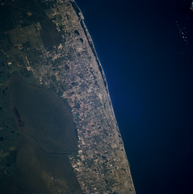 |
| STS070-710-004 Southeast Coastal Florida, U.S.A. July 1995 The corridor of the densely populated east coast of Florida between North Palm Beach (top) and Pompano Beach (bottom) contrasts with the dark blue Atlantic Ocean and the dull, uniform Arthur R. Marshall-Loxahatchee National Wildlife Refuge to the west. From an aerial perspective, many smaller cities that constitute the coastal region of Florida appear to coalesce into one large, intensely developed urban area. Vast, cultivated field patterns are discernible south of Lake Okeechobee (left margin). The faint straight lines (lower left corner) are part of a canal system that connects Lake Okeechobee with the southeast coast of Florida. |
| Images: | All Available Images Low-Resolution 264k |
|
| Mission: | STS070 |
|
| Roll - Frame: | 710 - 4 |
|
| Geographical Name: | USA-FLORIDA |
|
| Features: | BOYNTON BEACH, WETLANDS |
|
| Center Lat x Lon: | 26.5N x 80W |
|
| Film Exposure: | N | N=Normal exposure, U=Under exposed, O=Over exposed, F=out of Focus |
| Percentage of Cloud Cover-CLDP: | 0 |
|
| Camera:: | HB |
|
| Camera Tilt: | 24 | LO=Low Oblique, HO=High Oblique, NV=Near Vertical |
| Camera Focal Length: | 250 |
|
| Nadir to Photo Center Direction: | SW | The direction from the nadir to the center point, N=North, S=South, E=East, W=West |
| Stereo?: | Y | Y=Yes there is an adjacent picture of the same area, N=No there isn't |
| Orbit Number: | 64 |
|
| Date: | 19950717 | YYYYMMDD |
| Time: | 124725 | GMT HHMMSS |
| Nadir Lat: | 27.1N |
Latitude of suborbital point of spacecraft |
| Nadir Lon: | 79W |
Longitude of suborbital point of spacecraft |
| Sun Azimuth: | 79 | Clockwise angle in degrees from north to the sun measured at the nadir point |
| Space Craft Altitude: | 157 | nautical miles |
| Sun Elevation: | 28 | Angle in degrees between the horizon and the sun, measured at the nadir point |
| Land Views: | COAST, PLAIN |
|
| Water Views: | SWAMP, OCEAN, CANAL |
|
| Atmosphere Views: | |
|
| Man Made Views: | URBAN AREA, AGRICULTURE |
|
| City Views: | |
|
Photo is not associated with any sequences | ||
| NASA Home Page |
JSC Home Page |
JSC Digital Image Collection |
Earth Science & Remote Sensing |
|
This service is provided by the International Space Station program and the JSC Earth Science & Remote Sensing Unit, ARES Division, Exploration Integration Science Directorate.

|