
Geographic Region: USA-COLORADO
Feature: DENVER AREA, ROCKY MTS.
|
Geographic Region: USA-COLORADO Feature: DENVER AREA, ROCKY MTS. |
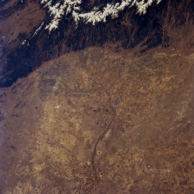 |
| STS068-257-039 Colorado Piedmont Area, Colorado, U.S.A. October 1994 Two distinctive landforms are apparent in this southwest-looking photograph--the Colorado Piedmont and the snow-covered higher elevations of the Front Range of the Rocky Mountains. The relatively flat Piedmont extends from just south of greater Denver (middle left edge of the photograph) to north of Fort Collins, sloping gradually west to east. The South Platte River and some of its tributaries flow north through the Denver area and turn east-northeast across northeastern Colorado, displaying a fairly broad floodplain (near bottom center). Numerous cultivated field patterns show widespread dry land farming throughout the region. |
| Images: | All Available Images Low-Resolution 365k |
|
| Mission: | STS068 |
|
| Roll - Frame: | 257 - 39 |
|
| Geographical Name: | USA-COLORADO |
|
| Features: | DENVER AREA, ROCKY MTS. |
|
| Center Lat x Lon: | 40.5N x 104.5W |
|
| Film Exposure: | N | N=Normal exposure, U=Under exposed, O=Over exposed, F=out of Focus |
| Percentage of Cloud Cover-CLDP: | 0 |
|
| Camera:: | HB |
|
| Camera Tilt: | 38 | LO=Low Oblique, HO=High Oblique, NV=Near Vertical |
| Camera Focal Length: | 100 |
|
| Nadir to Photo Center Direction: | S | The direction from the nadir to the center point, N=North, S=South, E=East, W=West |
| Stereo?: | Y | Y=Yes there is an adjacent picture of the same area, N=No there isn't |
| Orbit Number: | 167 |
|
| Date: | 19941010 | YYYYMMDD |
| Time: | 171248 | GMT HHMMSS |
| Nadir Lat: | 41.8N |
Latitude of suborbital point of spacecraft |
| Nadir Lon: | 103.9W |
Longitude of suborbital point of spacecraft |
| Sun Azimuth: | 151 | Clockwise angle in degrees from north to the sun measured at the nadir point |
| Space Craft Altitude: | 111 | nautical miles |
| Sun Elevation: | 37 | Angle in degrees between the horizon and the sun, measured at the nadir point |
| Land Views: | MOUNTAIN, PLAIN |
|
| Water Views: | RIVER |
|
| Atmosphere Views: | |
|
| Man Made Views: | AGRICULTURE |
|
| City Views: | |
|
Photo is not associated with any sequences | ||
| NASA Home Page |
JSC Home Page |
JSC Digital Image Collection |
Earth Science & Remote Sensing |
|
This service is provided by the International Space Station program and the JSC Earth Science & Remote Sensing Unit, ARES Division, Exploration Integration Science Directorate.

|