
Geographic Region: USA-MONTANA
Feature: MTS, BILLINGS, RED LODGE
|
Geographic Region: USA-MONTANA Feature: MTS, BILLINGS, RED LODGE |
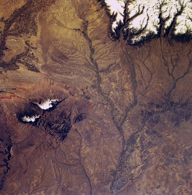 |
| STS068-249-036 Billings, Yellowstone River, and Pryor Mountains, Montana, U.S.A. October 1994 Billings, situated on the Yellowstone River in a valley surrounded by seven mountain ranges, is barely discernible in this south-southwest-looking, low-oblique photograph. The city is a trade and manufacturing center for the surrounding region and a shipping point for livestock, poultry, and wool. Oil refining, sugar refining, meat packing, and flour milling are the city's major industries. The eastern end of snow-covered Beartooth Plateau is visible in the top right of the photograph. Apparent along the bottom left is part of Yellowtail Dam on Bighorn Lake. West of the lake are the snowcapped peaks of the Pryor Mountains, the northern extension of the higher Bighorn Mountains (not discernible) further south in Wyoming. Irrigated fields in the Bighorn River Valley in Wyoming are visible. |
| Images: | All Available Images Low-Resolution 381k |
|
| Mission: | STS068 |
|
| Roll - Frame: | 249 - 36 |
|
| Geographical Name: | USA-MONTANA |
|
| Features: | MTS, BILLINGS, RED LODGE |
|
| Center Lat x Lon: | 45.0N x 109W |
|
| Film Exposure: | N | N=Normal exposure, U=Under exposed, O=Over exposed, F=out of Focus |
| Percentage of Cloud Cover-CLDP: | 0 |
|
| Camera:: | HB |
|
| Camera Tilt: | 21 | LO=Low Oblique, HO=High Oblique, NV=Near Vertical |
| Camera Focal Length: | 100 |
|
| Nadir to Photo Center Direction: | W | The direction from the nadir to the center point, N=North, S=South, E=East, W=West |
| Stereo?: | Y | Y=Yes there is an adjacent picture of the same area, N=No there isn't |
| Orbit Number: | 151 |
|
| Date: | 19941009 | YYYYMMDD |
| Time: | 173440 | GMT HHMMSS |
| Nadir Lat: | 44.9N |
Latitude of suborbital point of spacecraft |
| Nadir Lon: | 108.3W |
Longitude of suborbital point of spacecraft |
| Sun Azimuth: | 153 | Clockwise angle in degrees from north to the sun measured at the nadir point |
| Space Craft Altitude: | 110 | nautical miles |
| Sun Elevation: | 35 | Angle in degrees between the horizon and the sun, measured at the nadir point |
| Land Views: | MOUNTAIN, PLAIN, FAULT |
|
| Water Views: | RIVER |
|
| Atmosphere Views: | |
|
| Man Made Views: | AGRICULTURE |
|
| City Views: | BILLINGS |
|
Photo is not associated with any sequences | ||
| NASA Home Page |
JSC Home Page |
JSC Digital Image Collection |
Earth Science & Remote Sensing |
|
This service is provided by the International Space Station program and the JSC Earth Science & Remote Sensing Unit, ARES Division, Exploration Integration Science Directorate.

|