Geographic Region: GERMANY
Feature: STRIP MINES, AGR., FOREST
|
Geographic Region: GERMANY Feature: STRIP MINES, AGR., FOREST |
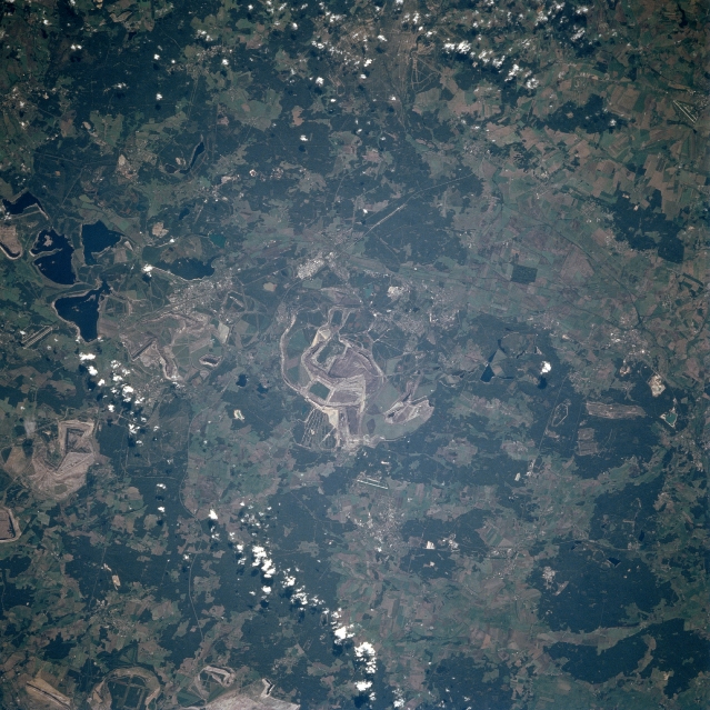 |
| STS068-246-061 Strip Mining Near Ruhland, Germany October, 1994 Lignite coal strip mines can be seen scattered throughout the image in this southeast-looking view. This part of eastern Germany some 70 miles (113 km) southeast of Berlin has numerous seams or outcrops of lignite, a low-grade brownish-black coal. The seams or outcrops of the Lignite are very close to the surface of the ground and can be mined by the removal of topsoil and vegetation. Near the left center of the image, water has filled older strip mines now depleted of lignite coal. Forests (darker greenish color) and agricultural field patterns (lighter colored landscape) are also seen scattered throughout the image. |
| Images: | All Available Images Low-Resolution 373k |
|
| Mission: | STS068 |
|
| Roll - Frame: | 246 - 61 |
|
| Geographical Name: | GERMANY |
|
| Features: | STRIP MINES, AGR., FOREST |
|
| Center Lat x Lon: | 51.5N x 14.0E |
|
| Film Exposure: | N | N=Normal exposure, U=Under exposed, O=Over exposed, F=out of Focus |
| Percentage of Cloud Cover-CLDP: | 5 |
|
| Camera:: | HB |
|
| Camera Tilt: | 27 | LO=Low Oblique, HO=High Oblique, NV=Near Vertical |
| Camera Focal Length: | 250 |
|
| Nadir to Photo Center Direction: | W | The direction from the nadir to the center point, N=North, S=South, E=East, W=West |
| Stereo?: | Y | Y=Yes there is an adjacent picture of the same area, N=No there isn't |
| Orbit Number: | 97 |
|
| Date: | 19941006 | YYYYMMDD |
| Time: | 094559 | GMT HHMMSS |
| Nadir Lat: | 51.1N |
Latitude of suborbital point of spacecraft |
| Nadir Lon: | 14.9E |
Longitude of suborbital point of spacecraft |
| Sun Azimuth: | 161 | Clockwise angle in degrees from north to the sun measured at the nadir point |
| Space Craft Altitude: | 115 | nautical miles |
| Sun Elevation: | 32 | Angle in degrees between the horizon and the sun, measured at the nadir point |
| Land Views: | HILL |
|
| Water Views: | LAKE |
|
| Atmosphere Views: | |
|
| Man Made Views: | MINING, AGRICULTURE |
|
| City Views: | |
|
Photo is not associated with any sequences | ||
| NASA Home Page |
JSC Home Page |
JSC Digital Image Collection |
Earth Science & Remote Sensing |
|
This service is provided by the International Space Station program and the JSC Earth Science & Remote Sensing Unit, ARES Division, Exploration Integration Science Directorate.

|