Geographic Region: TAIWAN
Feature: T'AI-PEI, RIVER, MTS. SED
|
Geographic Region: TAIWAN Feature: T'AI-PEI, RIVER, MTS. SED |
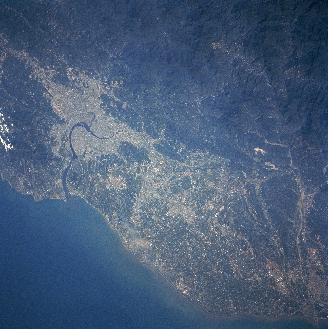 |
| STS068-239-090 Taipei Area, Taiwan October 1994 Located at the northern end of the island, Taipei (light colored area) is Taiwan's capital and largest city (estimated 1997 population more than 2.6 million people). The Tanshui River (dark curving feature) flows through Taipei, eventually emptying into the Formosa Strait. Parallel runways (light-colored linear feature) of Chiang Kai Shek International Airport are visible west of Taipei near the coast. The Chungyang Mountains can be identified by the darker landscape, particularly in the lower right corner of the image. This mountain range extends northeast/southwest for the entire length of the island. The mountains tend to have steep slopes and are densely forested. The darker terrain along the west coast is vegetated hills, while the lighter colored terrain shows the distribution of urban areas and farmland. |
| Images: | All Available Images Low-Resolution 383k |
|
| Mission: | STS068 |
|
| Roll - Frame: | 239 - 90 |
|
| Geographical Name: | TAIWAN |
|
| Features: | T'AI-PEI, RIVER, MTS. SED |
|
| Center Lat x Lon: | 25.0N x 121.5E |
|
| Film Exposure: | N | N=Normal exposure, U=Under exposed, O=Over exposed, F=out of Focus |
| Percentage of Cloud Cover-CLDP: | 5 |
|
| Camera:: | HB |
|
| Camera Tilt: | 43 | LO=Low Oblique, HO=High Oblique, NV=Near Vertical |
| Camera Focal Length: | 250 |
|
| Nadir to Photo Center Direction: | N | The direction from the nadir to the center point, N=North, S=South, E=East, W=West |
| Stereo?: | Y | Y=Yes there is an adjacent picture of the same area, N=No there isn't |
| Orbit Number: | 30 |
|
| Date: | 19941002 | YYYYMMDD |
| Time: | 064647 | GMT HHMMSS |
| Nadir Lat: | 23.3N |
Latitude of suborbital point of spacecraft |
| Nadir Lon: | 120.8E |
Longitude of suborbital point of spacecraft |
| Sun Azimuth: | 245 | Clockwise angle in degrees from north to the sun measured at the nadir point |
| Space Craft Altitude: | 118 | nautical miles |
| Sun Elevation: | 39 | Angle in degrees between the horizon and the sun, measured at the nadir point |
| Land Views: | COAST, MOUNTAIN, PLAIN |
|
| Water Views: | RIVER, SEDIMENT |
|
| Atmosphere Views: | |
|
| Man Made Views: | URBAN AREA, AIRPORT |
|
| City Views: | |
|
Photo is not associated with any sequences | ||
| NASA Home Page |
JSC Home Page |
JSC Digital Image Collection |
Earth Science & Remote Sensing |
|
This service is provided by the International Space Station program and the JSC Earth Science & Remote Sensing Unit, ARES Division, Exploration Integration Science Directorate.

|