Geographic Region: RUSSIAN FEDERATION
Feature: KURIL IS., ONEKOTAN I.
|
Geographic Region: RUSSIAN FEDERATION Feature: KURIL IS., ONEKOTAN I. |
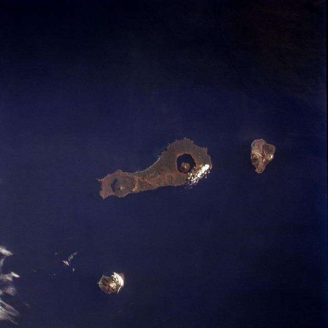 |
| STS068-231-054 Onekotan Island, Kuril Islands, Russia October 1994 Located near the northern end of the Kuril Islands, Onekotan Island (center of photograph) is another volcanic island that is part of the "Ring of Fire" that encircles the Pacific Ocean. This island is unique because a water-filled caldera is evident at both the north and the south ends of the island. The highest elevation on Onekotan Island is the smaller peak, which is 4367 feet (1330 meters) above sea level, that lies within the southern caldera. More recent secondary volcanic cones have formed in both calderas; the northern caldera has almost been filled by the subsidiary cone. Two other smaller volcanic peaks are also visible on this photograph--Makanrushi Island, 3834 feet (11 170 meters), to the northwest of Onekotan Island and Kharimkotan Island, 3976 feet (1210 meters), to the south. (Refer to STS-047-075-082 for a view of Atlasova Island, another of the volcanic islands in the Kuril Island chain.) |
| Images: | All Available Images Low-Resolution 52k |
|
| Mission: | STS068 |
|
| Roll - Frame: | 231 - 54 |
|
| Geographical Name: | RUSSIAN FEDERATION |
|
| Features: | KURIL IS., ONEKOTAN I. |
|
| Center Lat x Lon: | 49.5N x 154.5E |
|
| Film Exposure: | N | N=Normal exposure, U=Under exposed, O=Over exposed, F=out of Focus |
| Percentage of Cloud Cover-CLDP: | 5 |
|
| Camera:: | HB |
|
| Camera Tilt: | 18 | LO=Low Oblique, HO=High Oblique, NV=Near Vertical |
| Camera Focal Length: | 100 |
|
| Nadir to Photo Center Direction: | W | The direction from the nadir to the center point, N=North, S=South, E=East, W=West |
| Stereo?: | Y | Y=Yes there is an adjacent picture of the same area, N=No there isn't |
| Orbit Number: | 75 |
|
| Date: | 19941005 | YYYYMMDD |
| Time: | 011407 | GMT HHMMSS |
| Nadir Lat: | 49.4N |
Latitude of suborbital point of spacecraft |
| Nadir Lon: | 155.1E |
Longitude of suborbital point of spacecraft |
| Sun Azimuth: | 176 | Clockwise angle in degrees from north to the sun measured at the nadir point |
| Space Craft Altitude: | 116 | nautical miles |
| Sun Elevation: | 36 | Angle in degrees between the horizon and the sun, measured at the nadir point |
| Land Views: | ISLAND, VOLCANO, CRATER, COAST |
|
| Water Views: | OCEAN |
|
| Atmosphere Views: | |
|
| Man Made Views: | |
|
| City Views: | |
|
Photo is not associated with any sequences | ||
| NASA Home Page |
JSC Home Page |
JSC Digital Image Collection |
Earth Science & Remote Sensing |
|
This service is provided by the International Space Station program and the JSC Earth Science & Remote Sensing Unit, ARES Division, Exploration Integration Science Directorate.

|