
Geographic Region: USA-DELAWARE
Feature: COAST NEAR OCEAN CITY
|
Geographic Region: USA-DELAWARE Feature: COAST NEAR OCEAN CITY |
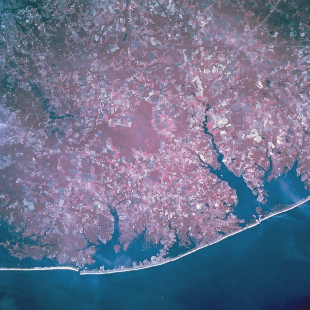 |
| STS068-202-096 Southeast Coast, Delaware & Maryland, U.S.A. October 1994 The east coast of southern Delaware and the east coast of Maryland share equal space in this northwest view of a color infrared image of their respective coastlines. The ability of the color infrared film product to differentiate the land-water boundaries help to identify even the short-flowing rivers that exist in this peninsula area of Maryland and Delaware. A series of bays aid in the location of specific geographic positions on the image. Starting at the north side of the picture (right edge) and moving south these bays include Rehoboth Bay and Indian River Bay (interconnected bays and both in Delaware) and Assawoman and Chincoteague Bays (both in Maryland-left edge). The sandy, barrier islands provide a tremendous tourist attraction during the summer months. Ocean City (Maryland), a major east coast resort city, is located on the southern end of a barrier island (lower middle part of image). The larger uniform looking red features show concentrations of woodlands; while the lighter reds (and non-red lands) and angular field patterns show where agricultural fields are located. |
| Images: | All Available Images Low-Resolution 354k |
|
| Mission: | STS068 |
|
| Roll - Frame: | 202 - 96 |
|
| Geographical Name: | USA-DELAWARE |
|
| Features: | COAST NEAR OCEAN CITY |
|
| Center Lat x Lon: | 38.5N x 75W |
|
| Film Exposure: | N | N=Normal exposure, U=Under exposed, O=Over exposed, F=out of Focus |
| Percentage of Cloud Cover-CLDP: | 10 |
|
| Camera:: | HB |
|
| Camera Tilt: | 22 | LO=Low Oblique, HO=High Oblique, NV=Near Vertical |
| Camera Focal Length: | 250 |
|
| Nadir to Photo Center Direction: | SE | The direction from the nadir to the center point, N=North, S=South, E=East, W=West |
| Stereo?: | N | Y=Yes there is an adjacent picture of the same area, N=No there isn't |
| Orbit Number: | 70 |
|
| Date: | 19941004 | YYYYMMDD |
| Time: | 175416 | GMT HHMMSS |
| Nadir Lat: | 38.9N |
Latitude of suborbital point of spacecraft |
| Nadir Lon: | 75.7W |
Longitude of suborbital point of spacecraft |
| Sun Azimuth: | 202 | Clockwise angle in degrees from north to the sun measured at the nadir point |
| Space Craft Altitude: | 117 | nautical miles |
| Sun Elevation: | 44 | Angle in degrees between the horizon and the sun, measured at the nadir point |
| Land Views: | COAST, PLAIN, ISLAND |
|
| Water Views: | BAY, OCEAN |
|
| Atmosphere Views: | |
|
| Man Made Views: | AGRICULTURE |
|
| City Views: | |
|
Photo is not associated with any sequences | ||
| NASA Home Page |
JSC Home Page |
JSC Digital Image Collection |
Earth Science & Remote Sensing |
|
This service is provided by the International Space Station program and the JSC Earth Science & Remote Sensing Unit, ARES Division, Exploration Integration Science Directorate.

|