Geographic Region: INDONESIA-WNG
Feature: NEAR NABIRE
|
Geographic Region: INDONESIA-WNG Feature: NEAR NABIRE |
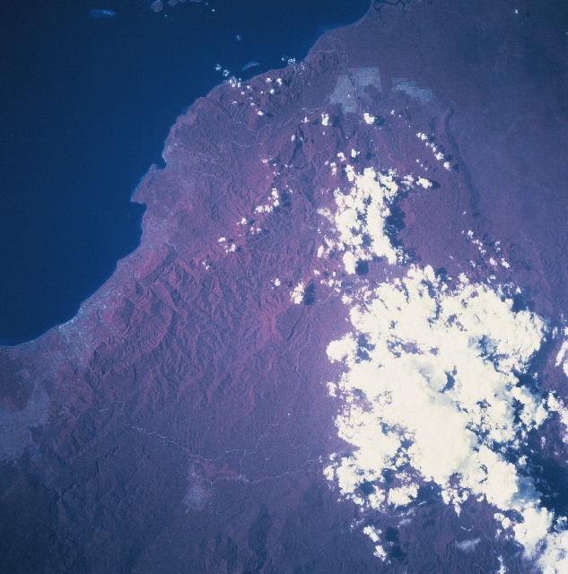 |
| STS068-202-032 Irian Jaya, Indonesia October 1994 The coastline around the southern end of the Gulf of Cenderawasih (very dark area) that includes Nabire (the lighter colored area along the coast near the left margin), a small port city, contrasts with dense vegetated tropical rainforest of Irian Jaya. The color infrared image (red colors are actually green vegetation) is very effective in showing the extensive ground cover of the rainforest canopy that overlays primarily a rugged, mountainous landscape, especially the interior. The angular, pinkish areas, mainly near the coast, show where the tropical rainforest has been cleared for development, either for agricultural purposes or the extractive industry. The lighter-colored lines are roads that have been cut through the mountainous, jungle-covered terrain. Clouds obscure part of the mountainous terrain immediately north of the Weyland Mountains. STS068-202-031 provides additional photographic coverage of the area southwest of this scene that includes the port city of Nabire. |
| Images: | All Available Images Low-Resolution 337k |
|
| Mission: | STS068 |
|
| Roll - Frame: | 202 - 32 |
|
| Geographical Name: | INDONESIA-WNG |
|
| Features: | NEAR NABIRE |
|
| Center Lat x Lon: | 3S x 135.5E |
|
| Film Exposure: | N | N=Normal exposure, U=Under exposed, O=Over exposed, F=out of Focus |
| Percentage of Cloud Cover-CLDP: | 25 |
|
| Camera:: | HB |
|
| Camera Tilt: | 25 | LO=Low Oblique, HO=High Oblique, NV=Near Vertical |
| Camera Focal Length: | 250 |
|
| Nadir to Photo Center Direction: | N | The direction from the nadir to the center point, N=North, S=South, E=East, W=West |
| Stereo?: | N | Y=Yes there is an adjacent picture of the same area, N=No there isn't |
| Orbit Number: | 62 |
|
| Date: | 19941004 | YYYYMMDD |
| Time: | 061700 | GMT HHMMSS |
| Nadir Lat: | 3.9S |
Latitude of suborbital point of spacecraft |
| Nadir Lon: | 135.4E |
Longitude of suborbital point of spacecraft |
| Sun Azimuth: | 268 | Clockwise angle in degrees from north to the sun measured at the nadir point |
| Space Craft Altitude: | 118 | nautical miles |
| Sun Elevation: | 38 | Angle in degrees between the horizon and the sun, measured at the nadir point |
| Land Views: | FOREST |
|
| Water Views: | |
|
| Atmosphere Views: | |
|
| Man Made Views: | |
|
| City Views: | |
|
Photo is not associated with any sequences | ||
| NASA Home Page |
JSC Home Page |
JSC Digital Image Collection |
Earth Science & Remote Sensing |
|
This service is provided by the International Space Station program and the JSC Earth Science & Remote Sensing Unit, ARES Division, Exploration Integration Science Directorate.

|