
Geographic Region: USA-MICHIGAN
Feature: HOUGHTON LAKE AREA
|
Geographic Region: USA-MICHIGAN Feature: HOUGHTON LAKE AREA |
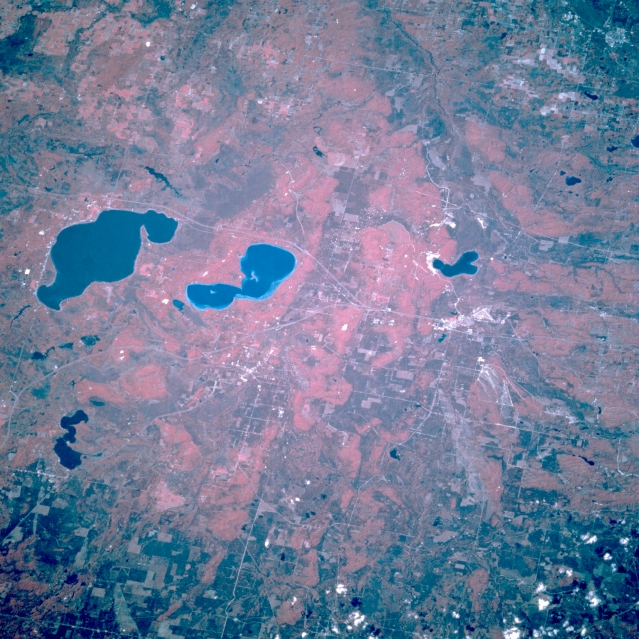 |
| STS068-201-068 Higgins Lake and Houghton Lake, Michigan, U.S.A. October 1994 This west-looking, low-oblique, color infrared photograph features the forests surrounding dark blue Houghton Lake (left center) and lighter blue Higgins Lake to the north. Two smaller lakes are discernible--Lake Margrethe north-northwest of Lake Higgins near the small resort city of Grayling (right of center) and Lake Saint Helen east of Lake Houghton. The area is a year-around resort and recreational area and provides lumber and wood products manufacturing. Farmland is limited in the glacial landscape of sandy hills and moraines. |
| Images: | All Available Images Low-Resolution 386k |
|
| Mission: | STS068 |
|
| Roll - Frame: | 201 - 68 |
|
| Geographical Name: | USA-MICHIGAN |
|
| Features: | HOUGHTON LAKE AREA |
|
| Center Lat x Lon: | 44.5N x 84.5W |
|
| Film Exposure: | N | N=Normal exposure, U=Under exposed, O=Over exposed, F=out of Focus |
| Percentage of Cloud Cover-CLDP: | 5 |
|
| Camera:: | HB |
|
| Camera Tilt: | 42 | LO=Low Oblique, HO=High Oblique, NV=Near Vertical |
| Camera Focal Length: | 250 |
|
| Nadir to Photo Center Direction: | W | The direction from the nadir to the center point, N=North, S=South, E=East, W=West |
| Stereo?: | N | Y=Yes there is an adjacent picture of the same area, N=No there isn't |
| Orbit Number: | 54 |
|
| Date: | 19941003 | YYYYMMDD |
| Time: | 181122 | GMT HHMMSS |
| Nadir Lat: | 44.9N |
Latitude of suborbital point of spacecraft |
| Nadir Lon: | 82.8W |
Longitude of suborbital point of spacecraft |
| Sun Azimuth: | 197 | Clockwise angle in degrees from north to the sun measured at the nadir point |
| Space Craft Altitude: | 117 | nautical miles |
| Sun Elevation: | 40 | Angle in degrees between the horizon and the sun, measured at the nadir point |
| Land Views: | FOREST |
|
| Water Views: | LAKE |
|
| Atmosphere Views: | |
|
| Man Made Views: | |
|
| City Views: | |
|
Photo is not associated with any sequences | ||
| NASA Home Page |
JSC Home Page |
JSC Digital Image Collection |
Earth Science & Remote Sensing |
|
This service is provided by the International Space Station program and the JSC Earth Science & Remote Sensing Unit, ARES Division, Exploration Integration Science Directorate.

|