Geographic Region: CANADA-BC
Feature: CANADIAN ROCKY MTS.
|
Geographic Region: CANADA-BC Feature: CANADIAN ROCKY MTS. |
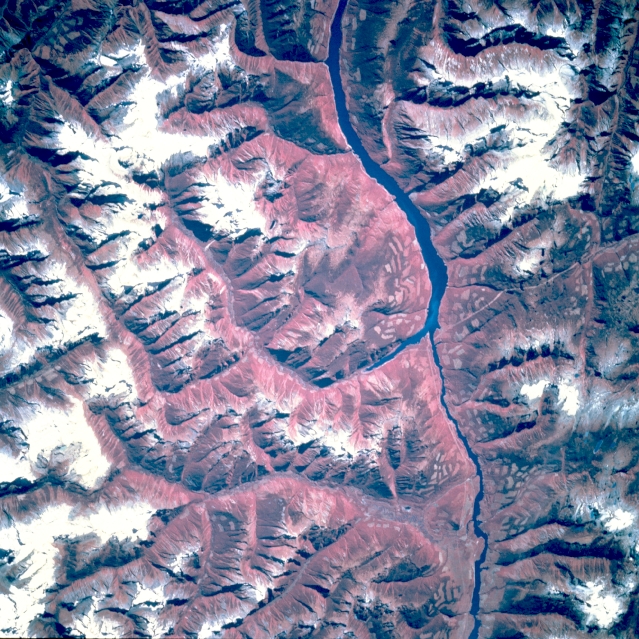 |
| STS068-201-111 Columbia River, British Columbia, Canada October 1994 The snow capped Canadian Rocky Mountains provide a dramatic contrast against the reddish (actually green forests) tree covered slopes of the numerous canyons along this section of the Columbia River just north of Revelstoke in this color infrared image. At the time that the picture was taken snow cover on the higher elevations generally exceed 9000 feet (2740 meters) above sea level. The angular shaped lighter colored pattern on many of the mountain slopes and in some of the valleys map the areas where trees have been removed as part of the large lumber industry found in British Columbia. |
| Images: | All Available Images Low-Resolution 427k |
|
| Mission: | STS068 |
|
| Roll - Frame: | 201 - 111 |
|
| Geographical Name: | CANADA-BC |
|
| Features: | CANADIAN ROCKY MTS. |
|
| Center Lat x Lon: | N x E |
|
| Film Exposure: | N | N=Normal exposure, U=Under exposed, O=Over exposed, F=out of Focus |
| Percentage of Cloud Cover-CLDP: | 0 |
|
| Camera:: | HB |
|
| Camera Tilt: | LO=Low Oblique, HO=High Oblique, NV=Near Vertical |
|
| Camera Focal Length: | 250 |
|
| Nadir to Photo Center Direction: | The direction from the nadir to the center point, N=North, S=South, E=East, W=West |
|
| Stereo?: | N | Y=Yes there is an adjacent picture of the same area, N=No there isn't |
| Orbit Number: | 55 |
|
| Date: | 19941003 | YYYYMMDD |
| Time: | 193747 | GMT HHMMSS |
| Nadir Lat: | 50.5N |
Latitude of suborbital point of spacecraft |
| Nadir Lon: | 116.3W |
Longitude of suborbital point of spacecraft |
| Sun Azimuth: | 181 | Clockwise angle in degrees from north to the sun measured at the nadir point |
| Space Craft Altitude: | 116 | nautical miles |
| Sun Elevation: | 36 | Angle in degrees between the horizon and the sun, measured at the nadir point |
| Land Views: | MOUNTAIN, VALLEY |
|
| Water Views: | RIVER |
|
| Atmosphere Views: | |
|
| Man Made Views: | DEFORESTATION |
|
| City Views: | |
|
Photo is not associated with any sequences | ||
| NASA Home Page |
JSC Home Page |
JSC Digital Image Collection |
Earth Science & Remote Sensing |
|
This service is provided by the International Space Station program and the JSC Earth Science & Remote Sensing Unit, ARES Division, Exploration Integration Science Directorate.

|