
Geographic Region: USA-IDAHO
Feature: SNAKE R, LEWISTON AREA
|
Geographic Region: USA-IDAHO Feature: SNAKE R, LEWISTON AREA |
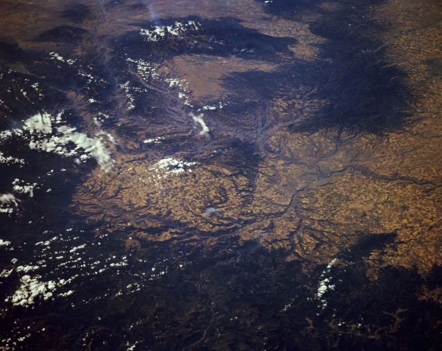 |
| STS068-174-154 Snake River, Lewiston, and the Clearwater Mountains, Idaho and Oregon, U.S.A October 1994 The Snake River is featured in this south-southwest-looking, low-oblique photograph as it travels from the west (right center) to the southeast at Lewiston, Idaho (midway between the center and right center of the photograph). As it winds to the southeast, the river proceeds through Hells Canyon National Recreation Area on the Idaho-Oregon border east of the rugged Wallowa Mountains near the top center of the photograph. Extending approximately 125 miles (200 kilometers) in a north-south orientation, Hells Canyon reaches a maximum depth of 7900 feet (2410 meters), making it one of the deepest canyons in the world. Visible are the forested Blue Mountains of Oregon and Washington near the upper right of the photograph and the forest-covered Clearwater Mountains, partially obscured by clouds, from the bottom right to near the top left corner of the photograph. The southeastern portion of the Columbia Plateau, with many agricultural field patterns, is discernible from the left of center to the right center of the photograph. |
| Images: | All Available Images Low-Resolution 299k |
|
| Mission: | STS068 |
|
| Roll - Frame: | 174 - 154 |
|
| Geographical Name: | USA-IDAHO |
|
| Features: | SNAKE R, LEWISTON AREA |
|
| Center Lat x Lon: | 46.5N x 117W |
|
| Film Exposure: | N | N=Normal exposure, U=Under exposed, O=Over exposed, F=out of Focus |
| Percentage of Cloud Cover-CLDP: | 5 |
|
| Camera:: | LH |
|
| Camera Tilt: | LO | LO=Low Oblique, HO=High Oblique, NV=Near Vertical |
| Camera Focal Length: | 250 |
|
| Nadir to Photo Center Direction: | SW | The direction from the nadir to the center point, N=North, S=South, E=East, W=West |
| Stereo?: | Y | Y=Yes there is an adjacent picture of the same area, N=No there isn't |
| Orbit Number: | 103 |
|
| Date: | 19941006 | YYYYMMDD |
| Time: | 183946 | GMT HHMMSS |
| Nadir Lat: | 48.3N |
Latitude of suborbital point of spacecraft |
| Nadir Lon: | 113.8W |
Longitude of suborbital point of spacecraft |
| Sun Azimuth: | 167 | Clockwise angle in degrees from north to the sun measured at the nadir point |
| Space Craft Altitude: | 115 | nautical miles |
| Sun Elevation: | 36 | Angle in degrees between the horizon and the sun, measured at the nadir point |
| Land Views: | MOUNTAIN, FOREST |
|
| Water Views: | RIVER |
|
| Atmosphere Views: | |
|
| Man Made Views: | AGRICULTURE |
|
| City Views: | |
|
Photo is not associated with any sequences | ||
| NASA Home Page |
JSC Home Page |
JSC Digital Image Collection |
Earth Science & Remote Sensing |
|
This service is provided by the International Space Station program and the JSC Earth Science & Remote Sensing Unit, ARES Division, Exploration Integration Science Directorate.

|