
Geographic Region: USA-NEW YORK
Feature: BUFFALO, FINGER L., AGR.
|
Geographic Region: USA-NEW YORK Feature: BUFFALO, FINGER L., AGR. |
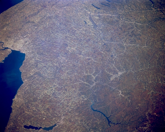 |
| STS068-173-100 Allegheny Plateau, New York October 1994 Covering the right portion of the image, the dissected uplands of the Allegheny Plateau (sometimes referred to as the Appalachian Plateau) can be seen in this east-looking view. The Alleghenies were formed by the folding and uplifting of sedimentary rocks, and have been reduced subsequently to their present state by erosion. Numerous valleys, which contain fertile and productive soils, are scattered throughout the region. The plateau area is rich in coal and timber along with iron ore, petroleum, and natural gas. A small section of Lake Ontario is visible in the upper left portion of the image. Lake Erie extends along the lower left to the center of the image. Near the bottom left of the image and inland from Lake Erie is Chautagua Lake. Chautagua Lake, a finger lake of sort, formed by a retreating glacier some 12000 to 15000 years ago, is 25 miles long (40 km) and about 2 miles (3 km) wide. The waters of the Allegheny Reservoir can be seen near the bottom center of the image. |
| Images: | All Available Images Low-Resolution 297k |
|
| Mission: | STS068 |
|
| Roll - Frame: | 173 - 100 |
|
| Geographical Name: | USA-NEW YORK |
|
| Features: | BUFFALO, FINGER L., AGR. |
|
| Center Lat x Lon: | 42.5N x 78.5W |
|
| Film Exposure: | N | N=Normal exposure, U=Under exposed, O=Over exposed, F=out of Focus |
| Percentage of Cloud Cover-CLDP: | 0 |
|
| Camera:: | LH |
|
| Camera Tilt: | 52 | LO=Low Oblique, HO=High Oblique, NV=Near Vertical |
| Camera Focal Length: | 250 |
|
| Nadir to Photo Center Direction: | NE | The direction from the nadir to the center point, N=North, S=South, E=East, W=West |
| Stereo?: | Y | Y=Yes there is an adjacent picture of the same area, N=No there isn't |
| Orbit Number: | 118 |
|
| Date: | 19941007 | YYYYMMDD |
| Time: | 165323 | GMT HHMMSS |
| Nadir Lat: | 40.7N |
Latitude of suborbital point of spacecraft |
| Nadir Lon: | 80W |
Longitude of suborbital point of spacecraft |
| Sun Azimuth: | 175 | Clockwise angle in degrees from north to the sun measured at the nadir point |
| Space Craft Altitude: | 111 | nautical miles |
| Sun Elevation: | 44 | Angle in degrees between the horizon and the sun, measured at the nadir point |
| Land Views: | PLATEAU, HILL, FOREST |
|
| Water Views: | LAKE, RIVER |
|
| Atmosphere Views: | |
|
| Man Made Views: | URBAN AREA, AGRICULTURE |
|
| City Views: | |
|
Photo is not associated with any sequences | ||
| NASA Home Page |
JSC Home Page |
JSC Digital Image Collection |
Earth Science & Remote Sensing |
|
This service is provided by the International Space Station program and the JSC Earth Science & Remote Sensing Unit, ARES Division, Exploration Integration Science Directorate.

|