
Geographic Region: USA-WYOMING
Feature: ABSAROKA RANGE, DRAINAGE
|
Geographic Region: USA-WYOMING Feature: ABSAROKA RANGE, DRAINAGE |
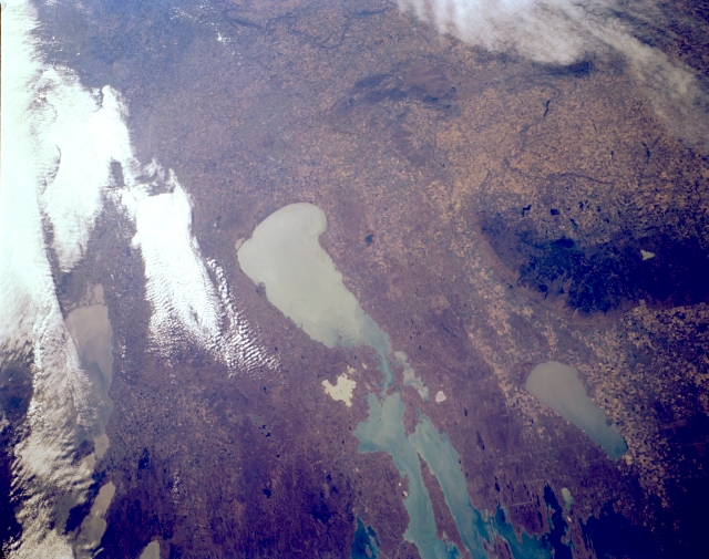 |
| STS068-172-172 Dauphin Lake; Lake Manitoba, Canada October 1994 One of the largest lakes in North America, Lake Manitoba can be seen in this south-looking low-oblique view. Covering nearly 1817 square miles (4706 sq. km.) and extending in length over 140 miles (225 km), Lake Manitoba is a remnant of the former Lake Agassiz, a glacial lake formed over 10,000 years ago when Ice Age glaciers were retreating northward. Former Lake Agassiz covered portions of present day northwest Minnesota, northeast North Dakota, southern Manitoba, and southwest Ontario. To the left of Lake Manitoba, some portions of Lake Winnipeg are visible through the clouds. To the right of Lake Manitoba is Lake Dauphin, another remnant of former Lake Agassiz, which covers an area of 200 square miles (518 sq. km.) |
| Images: | All Available Images Low-Resolution 284k |
|
| Mission: | STS068 |
|
| Roll - Frame: | 172 - 172 |
|
| Geographical Name: | USA-WYOMING |
|
| Features: | ABSAROKA RANGE, DRAINAGE |
|
| Center Lat x Lon: | 44.5N x 108.5W |
|
| Film Exposure: | F | N=Normal exposure, U=Under exposed, O=Over exposed, F=out of Focus |
| Percentage of Cloud Cover-CLDP: | 0 |
|
| Camera:: | LH |
|
| Camera Tilt: | 26 | LO=Low Oblique, HO=High Oblique, NV=Near Vertical |
| Camera Focal Length: | 250 |
|
| Nadir to Photo Center Direction: | W | The direction from the nadir to the center point, N=North, S=South, E=East, W=West |
| Stereo?: | N | Y=Yes there is an adjacent picture of the same area, N=No there isn't |
| Orbit Number: | 151 |
|
| Date: | 19941009 | YYYYMMDD |
| Time: | 173448 | GMT HHMMSS |
| Nadir Lat: | 44.4N |
Latitude of suborbital point of spacecraft |
| Nadir Lon: | 107.6W |
Longitude of suborbital point of spacecraft |
| Sun Azimuth: | 154 | Clockwise angle in degrees from north to the sun measured at the nadir point |
| Space Craft Altitude: | 110 | nautical miles |
| Sun Elevation: | 36 | Angle in degrees between the horizon and the sun, measured at the nadir point |
| Land Views: | FOREST |
|
| Water Views: | LAKE |
|
| Atmosphere Views: | |
|
| Man Made Views: | AGRICULTURE |
|
| City Views: | |
|
Photo is not associated with any sequences | ||
| NASA Home Page |
JSC Home Page |
JSC Digital Image Collection |
Earth Science & Remote Sensing |
|
This service is provided by the International Space Station program and the JSC Earth Science & Remote Sensing Unit, ARES Division, Exploration Integration Science Directorate.

|