
Geographic Region: USA-ARKANSAS
Feature: LAKE OUACHITA, ARKANSAS RIVER
|
Geographic Region: USA-ARKANSAS Feature: LAKE OUACHITA, ARKANSAS RIVER |
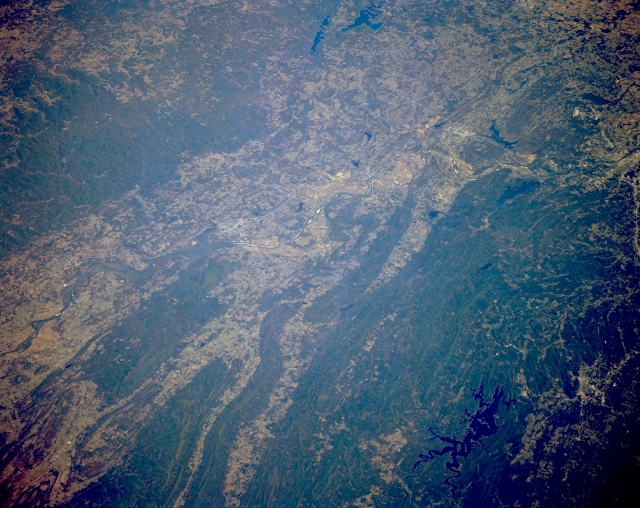 |
| STS068-167-00W Arkansas River Valley, Arkansas, U.S.A. October 1994 A section of the winding, southeast-trending Arkansas River is visible as it flows through Little Rock (middle right edge). This part of the river valley is bordered on the north by the Boston Mountains and on the south by the eastern end of the folded Ouachita Mountains. Individual east-west oriented mountain ridges and valleys are easily discernible north of the Ouachita Mountains. Several dark reservoirs are apparent--Lake Maumelle and Lake Conway, two of the larger reservoirs north of Little Rock, and dark, crablike Lake Ouachita (lower right corner) southwest of Little Rock. Southeast of Lake Ouachita is Hot Springs, a resort area. Cultivated field patterns are observed in the valleys. |
| Images: | All Available Images Low-Resolution 316k |
|
| Mission: | STS068 |
|
| Roll - Frame: | 167 - W |
|
| Geographical Name: | USA-ARKANSAS |
|
| Features: | LAKE OUACHITA, ARKANSAS RIVER |
|
| Center Lat x Lon: | 35.0N x 93W |
|
| Film Exposure: | N | N=Normal exposure, U=Under exposed, O=Over exposed, F=out of Focus |
| Percentage of Cloud Cover-CLDP: | 0 |
|
| Camera:: | LH |
|
| Camera Tilt: | 50 | LO=Low Oblique, HO=High Oblique, NV=Near Vertical |
| Camera Focal Length: | 250 |
|
| Nadir to Photo Center Direction: | NE | The direction from the nadir to the center point, N=North, S=South, E=East, W=West |
| Stereo?: | Y | Y=Yes there is an adjacent picture of the same area, N=No there isn't |
| Orbit Number: | 151 |
|
| Date: | 19941009 | YYYYMMDD |
| Time: | 173832 | GMT HHMMSS |
| Nadir Lat: | 33.6N |
Latitude of suborbital point of spacecraft |
| Nadir Lon: | 94.7W |
Longitude of suborbital point of spacecraft |
| Sun Azimuth: | 169 | Clockwise angle in degrees from north to the sun measured at the nadir point |
| Space Craft Altitude: | 111 | nautical miles |
| Sun Elevation: | 50 | Angle in degrees between the horizon and the sun, measured at the nadir point |
| Land Views: | VALLEY, MOUNTAIN, FOREST |
|
| Water Views: | RIVER, LAKE |
|
| Atmosphere Views: | |
|
| Man Made Views: | AGRICULTURE |
|
| City Views: | |
|
Photo is not associated with any sequences | ||
| NASA Home Page |
JSC Home Page |
JSC Digital Image Collection |
Earth Science & Remote Sensing |
|
This service is provided by the International Space Station program and the JSC Earth Science & Remote Sensing Unit, ARES Division, Exploration Integration Science Directorate.

|