Geographic Region: CANADA-NS
Feature: HALIFAX, NEW GLASGOW
|
Geographic Region: CANADA-NS Feature: HALIFAX, NEW GLASGOW |
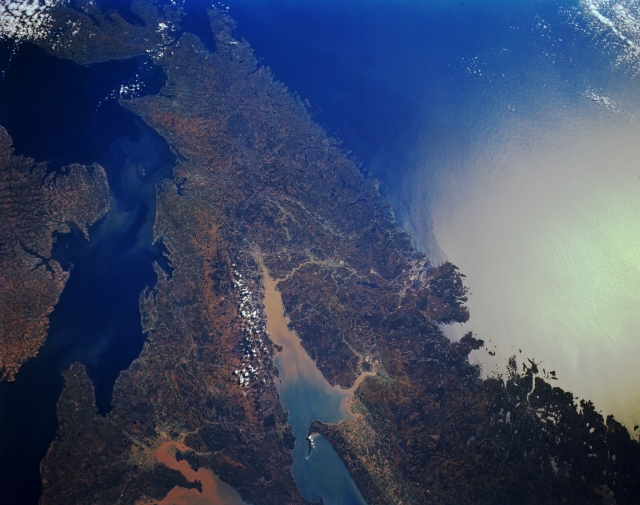 |
| STS068-161-038 Minas Basin, Nova Scotia, Canada October 1994 The rugged coastline of the peninsular Maritime Province of Nova Scotia is particularly accentuated in this synoptic view of central Nova Scotia. Two fingers of the larger Bay of Fundy are visible in this small scale image, the Cumberland Basin to the north and the V-shaped Minas Basin to the east. The largest tidal fluctuations in the world, sometimes exceeding 50 feet (15 meters), create a constant agitation in the sediment that is suspended in these basins. This can be seen in the discoloration at the head of the two bays. The Northumberland Straits is the body of water that separates Nova Scotia from Prince Edward Island (left center). The Strait of Canso that separates the mainland of Nova Scotia from Cape Breton Island is barely visible near top left. The urban, built-up area of Halifax is located along the east coast. The bright spot towards the right side of the picture is caused by the sun reflecting off of the water surface of the Atlantic Ocean. This is called sunglint or sunglitter. |
| Images: | All Available Images Low-Resolution 252k |
|
| Mission: | STS068 |
|
| Roll - Frame: | 161 - 38 |
|
| Geographical Name: | CANADA-NS |
|
| Features: | HALIFAX, NEW GLASGOW |
|
| Center Lat x Lon: | 45.0N x 63.5W |
|
| Film Exposure: | N | N=Normal exposure, U=Under exposed, O=Over exposed, F=out of Focus |
| Percentage of Cloud Cover-CLDP: | 5 |
|
| Camera:: | LH |
|
| Camera Tilt: | 21 | LO=Low Oblique, HO=High Oblique, NV=Near Vertical |
| Camera Focal Length: | 90 |
|
| Nadir to Photo Center Direction: | SE | The direction from the nadir to the center point, N=North, S=South, E=East, W=West |
| Stereo?: | N | Y=Yes there is an adjacent picture of the same area, N=No there isn't |
| Orbit Number: | 117 |
|
| Date: | 19941007 | YYYYMMDD |
| Time: | 152305 | GMT HHMMSS |
| Nadir Lat: | 45.4N |
Latitude of suborbital point of spacecraft |
| Nadir Lon: | 64.1W |
Longitude of suborbital point of spacecraft |
| Sun Azimuth: | 167 | Clockwise angle in degrees from north to the sun measured at the nadir point |
| Space Craft Altitude: | 111 | nautical miles |
| Sun Elevation: | 38 | Angle in degrees between the horizon and the sun, measured at the nadir point |
| Land Views: | PENINSULA |
|
| Water Views: | BAY, STRAIT |
|
| Atmosphere Views: | |
|
| Man Made Views: | |
|
| City Views: | |
|
Photo is not associated with any sequences | ||
| NASA Home Page |
JSC Home Page |
JSC Digital Image Collection |
Earth Science & Remote Sensing |
|
This service is provided by the International Space Station program and the JSC Earth Science & Remote Sensing Unit, ARES Division, Exploration Integration Science Directorate.

|