
Geographic Region: CHINA
Feature: KUNLUN MTS., TIBET PLAT.
|
Geographic Region: CHINA Feature: KUNLUN MTS., TIBET PLAT. |
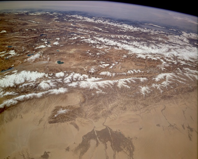 |
| STS068-158-00C Takla Makan Desert, Kunlun Mountains, and Tibetan Plateau, China October 1994 Viewing north to south, three major physiographic features are clearly seen in this panorama of western China--the southern fringe of the Takla Makan Desert, the high Kunlun Mountains, and the Tibetan Plateau. Most of the area shown in this photograph receives less than 10 inches (25 centimeters) of precipitation annually; most surface water that flows through the valleys and into the desert comes from snowmelt in the high mountains. Several major north-flowing watercourses (darker areas) that allow irrigated agriculture extend into the otherwise nonvegetated southern fringe of the Takla Makan Desert. The city of Hotan is not discernible at this scale; however, it lies between two stream channels within the darker delta. The snowcapped, generally east-west trending Kunlun Mountains, with most peaks exceeding 20 000 feet (7000 meters), are a major physical barrier between the Takla Makan Desert and the extensive, elevated, arid Tibetan Plateau. Basin elevations within the plateau average approximately 17 000 feet (5180 meters). The lakes on the plateau result from snowmelt in the surrounding mountains. This mountainous plateau, with most major fault structures having an east-west orientation, was formed and continues to be modified by the collision of the Australian-Indian Plate and the Eurasian Plate. |
| Images: | All Available Images Low-Resolution 109k |
|
| Mission: | STS068 |
|
| Roll - Frame: | 158 - C |
|
| Geographical Name: | CHINA |
|
| Features: | KUNLUN MTS., TIBET PLAT. |
|
| Center Lat x Lon: | 35.0N x 79.5E |
|
| Film Exposure: | N | N=Normal exposure, U=Under exposed, O=Over exposed, F=out of Focus |
| Percentage of Cloud Cover-CLDP: | 5 |
|
| Camera:: | LH |
|
| Camera Tilt: | HO | LO=Low Oblique, HO=High Oblique, NV=Near Vertical |
| Camera Focal Length: | 90 |
|
| Nadir to Photo Center Direction: | The direction from the nadir to the center point, N=North, S=South, E=East, W=West |
|
| Stereo?: | N | Y=Yes there is an adjacent picture of the same area, N=No there isn't |
| Orbit Number: | |
|
| Date: | 1994____ | YYYYMMDD |
| Time: | GMT HHMMSS |
|
| Nadir Lat: | N |
Latitude of suborbital point of spacecraft |
| Nadir Lon: | E |
Longitude of suborbital point of spacecraft |
| Sun Azimuth: | Clockwise angle in degrees from north to the sun measured at the nadir point |
|
| Space Craft Altitude: | nautical miles |
|
| Sun Elevation: | Angle in degrees between the horizon and the sun, measured at the nadir point |
|
| Land Views: | MOUNTAIN, PLATEAU, FAULT, BASIN, DESERT |
|
| Water Views: | RIVER, LAKE, DELTA |
|
| Atmosphere Views: | |
|
| Man Made Views: | AGRICULTURE |
|
| City Views: | |
|
Photo is not associated with any sequences | ||
| NASA Home Page |
JSC Home Page |
JSC Digital Image Collection |
Earth Science & Remote Sensing |
|
This service is provided by the International Space Station program and the JSC Earth Science & Remote Sensing Unit, ARES Division, Exploration Integration Science Directorate.

|