Geographic Region: AUSTRALIA-WA
Feature: DRY RIVERS,LAKES,AGRICULTURE
|
Geographic Region: AUSTRALIA-WA Feature: DRY RIVERS,LAKES,AGRICULTURE |
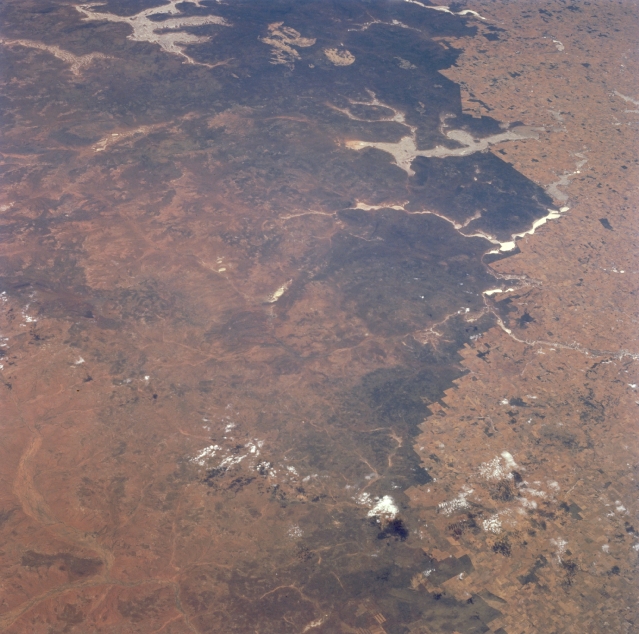 |
| STS066-089-019 Lake Moore Area, Western Australia, Australia November 1994 Although the bottom half of this easterly looking, low oblique image presents a non-descriptive landscape, the numerous, large dry lake-beds (lighter features) in the upper half help to locate and identify specific features. For example, the multi-fingered (5 "arms") dry lake in the upper left corner of the image is Lake Barlee. The other sizable dry lake, Lake Moore, is visible in the upper right quadrant. The highly reflective (whitish-looking, elongated feature near right middle) surface, Mongers Lake, suggests that there may be some sun reflection off of standing water in this normally dry lake at the time that this photograph was acquired. Western Australia gets drier and more barren to the north and east. The dramatic color change shows the abrupt change as a result of man's impact on the land use pattern. The darker landscape is a more primitive, naturally occurring environment and the lighter landscape shows man's ability to change the landscape. In some cases the straight lines show where fences are located. |
| Images: | All Available Images Low-Resolution 323k |
|
| Mission: | STS066 |
|
| Roll - Frame: | 89 - 19 |
|
| Geographical Name: | AUSTRALIA-WA |
|
| Features: | DRY RIVERS,LAKES,AGRICULTURE |
|
| Center Lat x Lon: | 28S x 115.5E |
|
| Film Exposure: | N | N=Normal exposure, U=Under exposed, O=Over exposed, F=out of Focus |
| Percentage of Cloud Cover-CLDP: | 5 |
|
| Camera:: | HB |
|
| Camera Tilt: | 39 | LO=Low Oblique, HO=High Oblique, NV=Near Vertical |
| Camera Focal Length: | 100 |
|
| Nadir to Photo Center Direction: | SE | The direction from the nadir to the center point, N=North, S=South, E=East, W=West |
| Stereo?: | Y | Y=Yes there is an adjacent picture of the same area, N=No there isn't |
| Orbit Number: | 37 |
|
| Date: | 19941106 | YYYYMMDD |
| Time: | 003745 | GMT HHMMSS |
| Nadir Lat: | 26.5S |
Latitude of suborbital point of spacecraft |
| Nadir Lon: | 113.9E |
Longitude of suborbital point of spacecraft |
| Sun Azimuth: | 89 | Clockwise angle in degrees from north to the sun measured at the nadir point |
| Space Craft Altitude: | 161 | nautical miles |
| Sun Elevation: | 40 | Angle in degrees between the horizon and the sun, measured at the nadir point |
| Land Views: | |
|
| Water Views: | SUNGLINT, PLAYA |
|
| Atmosphere Views: | |
|
| Man Made Views: | |
|
| City Views: | |
|
Photo is not associated with any sequences | ||
| NASA Home Page |
JSC Home Page |
JSC Digital Image Collection |
Earth Science & Remote Sensing |
|
This service is provided by the International Space Station program and the JSC Earth Science & Remote Sensing Unit, ARES Division, Exploration Integration Science Directorate.

|