
Geographic Region: USA-WISCONSIN
Feature: MINNEAPOLIS, MISSISSIPPI
|
Geographic Region: USA-WISCONSIN Feature: MINNEAPOLIS, MISSISSIPPI |
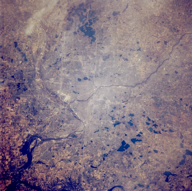 |
| STS066-124-046 Minneapolis and Saint Paul, Minnesota, U.S.A. November 1994 The twin cities of Minneapolis and Saint Paul, separated by the Mississippi River, are featured in this northwest-looking, low-oblique photograph. The Minnesota River enters the Mississippi east of Charles Lindbergh International Airport (left center). Minneapolis, west of the Mississippi River at Saint Anthony Falls, and Saint Paul, on the east side, are ports of entry and major industrial and rail hubs in a vast grain and cattle area. The state capitol in Saint Paul is modeled after Saint Peter's Basilica in Vatican City and has the largest unsupported marble dome in the world. Numerous lakes and parks are scattered throughout Minneapolis and Saint Paul. The Saint Croix River, east of Saint Paul, is barely discernible (bottom left to the bottom center). |
| Images: | All Available Images Low-Resolution 382k |
|
| Mission: | STS066 |
|
| Roll - Frame: | 124 - 46 |
|
| Geographical Name: | USA-WISCONSIN |
|
| Features: | MINNEAPOLIS, MISSISSIPPI |
|
| Center Lat x Lon: | 45.0N x 93W |
|
| Film Exposure: | N | N=Normal exposure, U=Under exposed, O=Over exposed, F=out of Focus |
| Percentage of Cloud Cover-CLDP: | 5 |
|
| Camera:: | HB |
|
| Camera Tilt: | 23 | LO=Low Oblique, HO=High Oblique, NV=Near Vertical |
| Camera Focal Length: | 100 |
|
| Nadir to Photo Center Direction: | W | The direction from the nadir to the center point, N=North, S=South, E=East, W=West |
| Stereo?: | N | Y=Yes there is an adjacent picture of the same area, N=No there isn't |
| Orbit Number: | 112 |
|
| Date: | 19941110 | YYYYMMDD |
| Time: | 163330 | GMT HHMMSS |
| Nadir Lat: | 45.2N |
Latitude of suborbital point of spacecraft |
| Nadir Lon: | 91.9W |
Longitude of suborbital point of spacecraft |
| Sun Azimuth: | 159 | Clockwise angle in degrees from north to the sun measured at the nadir point |
| Space Craft Altitude: | 158 | nautical miles |
| Sun Elevation: | 25 | Angle in degrees between the horizon and the sun, measured at the nadir point |
| Land Views: | |
|
| Water Views: | RIVER, LAKE |
|
| Atmosphere Views: | |
|
| Man Made Views: | URBAN AREA, AIRPORT |
|
| City Views: | MINNEAPOLIS, SAINT PAUL |
|
Photo is not associated with any sequences | ||
| NASA Home Page |
JSC Home Page |
JSC Digital Image Collection |
Earth Science & Remote Sensing |
|
This service is provided by the International Space Station program and the JSC Earth Science & Remote Sensing Unit, ARES Division, Exploration Integration Science Directorate.

|