Geographic Region: JAPAN
Feature: SADO ISLAND, ISLAND WAKE
|
Geographic Region: JAPAN Feature: SADO ISLAND, ISLAND WAKE |
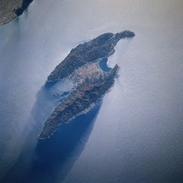 |
| STS066-117-034 Sado Island, Japan November 1994 The paralleling, northeast-southwest aligned mountains of Sado Island are connected in the middle by a plain. The island is separated from the west coast of Honshu Island by 19 miles (30 km). A small section of the Echigo Plain and a small coastal mountain (darker feature) located south of the city of Niigata are visible in the upper left corner of the image. Administratively Sado Island is part of Niigata prefecture. Notice that the sun's reflection off the water's surface (a phenomenon known as sunglint or sun glitter) has created a light colored image. The sunglint does identify a dark area north of the island, thereby providing a clue as to the direction of the water flow or current around Sado Island (in this case flowing from south to north), creating an island wake along the north side of the island. |
| Images: | All Available Images Low-Resolution 299k |
|
| Mission: | STS066 |
|
| Roll - Frame: | 117 - 34 |
|
| Geographical Name: | JAPAN |
|
| Features: | SADO ISLAND, ISLAND WAKE |
|
| Center Lat x Lon: | 38.0N x 138.5E |
|
| Film Exposure: | N | N=Normal exposure, U=Under exposed, O=Over exposed, F=out of Focus |
| Percentage of Cloud Cover-CLDP: | 0 |
|
| Camera:: | HB |
|
| Camera Tilt: | 37 | LO=Low Oblique, HO=High Oblique, NV=Near Vertical |
| Camera Focal Length: | 100 |
|
| Nadir to Photo Center Direction: | SE | The direction from the nadir to the center point, N=North, S=South, E=East, W=West |
| Stereo?: | Y | Y=Yes there is an adjacent picture of the same area, N=No there isn't |
| Orbit Number: | 86 |
|
| Date: | 19941109 | YYYYMMDD |
| Time: | 012044 | GMT HHMMSS |
| Nadir Lat: | 39.5N |
Latitude of suborbital point of spacecraft |
| Nadir Lon: | 137.2E |
Longitude of suborbital point of spacecraft |
| Sun Azimuth: | 159 | Clockwise angle in degrees from north to the sun measured at the nadir point |
| Space Craft Altitude: | 161 | nautical miles |
| Sun Elevation: | 31 | Angle in degrees between the horizon and the sun, measured at the nadir point |
| Land Views: | ISLAND, MOUNTAIN, PLAIN |
|
| Water Views: | ISLAND WAKE, SUNGLINT |
|
| Atmosphere Views: | |
|
| Man Made Views: | |
|
| City Views: | |
|
Photo is not associated with any sequences | ||
| NASA Home Page |
JSC Home Page |
JSC Digital Image Collection |
Earth Science & Remote Sensing |
|
This service is provided by the International Space Station program and the JSC Earth Science & Remote Sensing Unit, ARES Division, Exploration Integration Science Directorate.

|