Geographic Region: USA-TEXAS
Feature: LAREDO, RIO GRANDE
|
Geographic Region: USA-TEXAS Feature: LAREDO, RIO GRANDE |
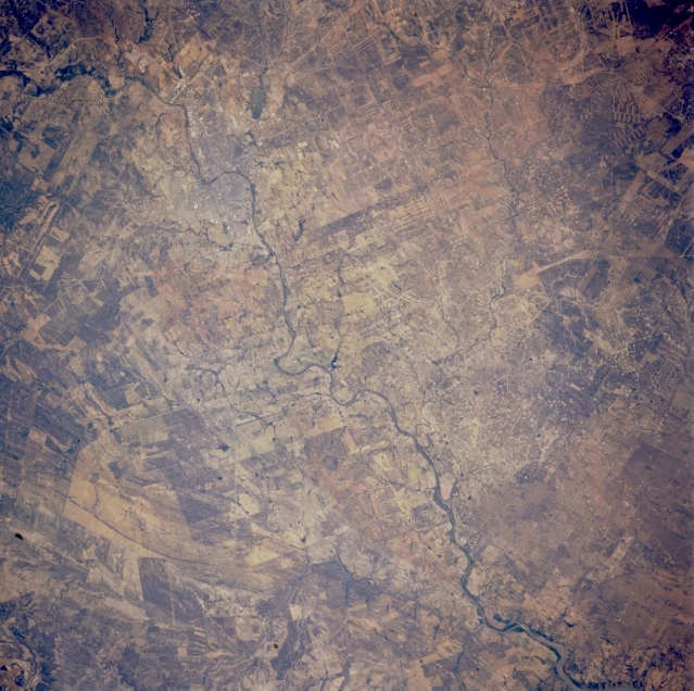 |
| STS065-100-006 Rio Grande, Texas, U.S.A. and Mexico July 1994 The Rio Grande almost equally divides this semiarid landscape with the United States on the north side of the river and Mexico on the south. The outline of the border towns of Laredo (United States) and Nuevo Laredo (Mexico) are barely discernible where the river makes a sharp course change from south to east. Much of the dry region consists of sandy soils derived from underlying sandstone rocks. Land ownership boundaries provide distinctive field patterns on both sides of the U.S.-Mexico border. |
| Images: | All Available Images Low-Resolution 369k |
|
| Mission: | STS065 |
|
| Roll - Frame: | 100 - 6 |
|
| Geographical Name: | USA-TEXAS |
|
| Features: | LAREDO, RIO GRANDE |
|
| Center Lat x Lon: | 27.5N x 99.5W |
|
| Film Exposure: | N | N=Normal exposure, U=Under exposed, O=Over exposed, F=out of Focus |
| Percentage of Cloud Cover-CLDP: | 0 |
|
| Camera:: | HB |
|
| Camera Tilt: | LO | LO=Low Oblique, HO=High Oblique, NV=Near Vertical |
| Camera Focal Length: | 250 |
|
| Nadir to Photo Center Direction: | The direction from the nadir to the center point, N=North, S=South, E=East, W=West |
|
| Stereo?: | Y | Y=Yes there is an adjacent picture of the same area, N=No there isn't |
| Orbit Number: | |
|
| Date: | 199407__ | YYYYMMDD |
| Time: | GMT HHMMSS |
|
| Nadir Lat: | N |
Latitude of suborbital point of spacecraft |
| Nadir Lon: | E |
Longitude of suborbital point of spacecraft |
| Sun Azimuth: | Clockwise angle in degrees from north to the sun measured at the nadir point |
|
| Space Craft Altitude: | nautical miles |
|
| Sun Elevation: | Angle in degrees between the horizon and the sun, measured at the nadir point |
|
| Land Views: | PLAIN, RANGE |
|
| Water Views: | RIVER |
|
| Atmosphere Views: | |
|
| Man Made Views: | |
|
| City Views: | |
|
Photo is not associated with any sequences | ||
| NASA Home Page |
JSC Home Page |
JSC Digital Image Collection |
Earth Science & Remote Sensing |
|
This service is provided by the International Space Station program and the JSC Earth Science & Remote Sensing Unit, ARES Division, Exploration Integration Science Directorate.

|