
Geographic Region: USA-WASHINGTON
Feature: MOUNT RAINIER
|
Geographic Region: USA-WASHINGTON Feature: MOUNT RAINIER |
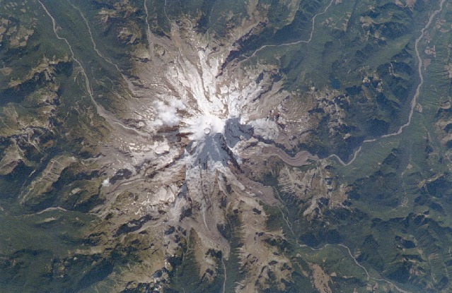 |
| STS064-051-027 Mount Rainier, Washington, U.S.A. September 1994 Mount Rainier, the highest peak in the Cascade Range at 14 410 feet (4392 meters) with its many glaciers, is the focal point of this near-vertical photograph. A massive stratovolcano with 27 named glaciers and many minor ones, Mount Rainier supports the largest glacier system in the 48 contiguous states. Visible in the photograph are deep cirques, glacier-carved valleys, and sharp ridges on the slopes of the mountain that testify to a much more extensive glaciation during the ice age. Located approximately 40 miles (64 kilometers) southeast of the Seattle-Tacoma area, the volcano has been dormant since a small explosive eruption in 1850. Mount Rainier began to form from a cinder cone nearly 1 million years ago and is estimated to have reached a height of more than 16 000 feet (4880 meters) above sea level. Geologists speculate that the former summit was destroyed about 6000 years ago by a combination of explosions, landslides, and mudflows. The largest avalanche in recent times occurred in December 1963, when a 2-square-mile (5-square-kilometer) portion of Emmons Glacier, the largest glacier on the mountain, and the upper White River Valley were covered by broken rock and chunks of ice. The surrounding mountains and lower slopes of Mount Rainier are mantled by dense coniferous forests. Mount Rainier, part of Mount Rainier National Park, is a famous ski and recreation resort. |
| Images: | All Available Images Low-Resolution 105k |
|
| Mission: | STS064 |
|
| Roll - Frame: | 51 - 27 |
|
| Geographical Name: | USA-WASHINGTON |
|
| Features: | MOUNT RAINIER |
|
| Center Lat x Lon: | 47.0N x 122W |
|
| Film Exposure: | N=Normal exposure, U=Under exposed, O=Over exposed, F=out of Focus |
|
| Percentage of Cloud Cover-CLDP: | 0 |
|
| Camera:: | ||
| Camera Tilt: | NV | LO=Low Oblique, HO=High Oblique, NV=Near Vertical |
| Camera Focal Length: | |
|
| Nadir to Photo Center Direction: | The direction from the nadir to the center point, N=North, S=South, E=East, W=West |
|
| Stereo?: | Y=Yes there is an adjacent picture of the same area, N=No there isn't |
|
| Orbit Number: | |
|
| Date: | 199409__ | YYYYMMDD |
| Time: | GMT HHMMSS |
|
| Nadir Lat: | N |
Latitude of suborbital point of spacecraft |
| Nadir Lon: | E |
Longitude of suborbital point of spacecraft |
| Sun Azimuth: | Clockwise angle in degrees from north to the sun measured at the nadir point |
|
| Space Craft Altitude: | nautical miles |
|
| Sun Elevation: | Angle in degrees between the horizon and the sun, measured at the nadir point |
|
| Land Views: | MOUNTAIN, VOLCANO, GLACIER, FOREST, RANGE, CRATER |
|
| Water Views: | RIVER |
|
| Atmosphere Views: | |
|
| Man Made Views: | |
|
| City Views: | |
|
Photo is not associated with any sequences | ||
| NASA Home Page |
JSC Home Page |
JSC Digital Image Collection |
Earth Science & Remote Sensing |
|
This service is provided by the International Space Station program and the JSC Earth Science & Remote Sensing Unit, ARES Division, Exploration Integration Science Directorate.

|