
Geographic Region: USA-ARIZONA
Feature: PHOENIX, LAKE PLEASANT
|
Geographic Region: USA-ARIZONA Feature: PHOENIX, LAKE PLEASANT |
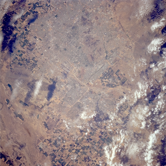 |
| STS064-213-074 Metropolitan Phoenix, Arizona, U.S.A. September 1994 Clouds and shadows obscure some of the landscape in this photograph; however, most of urban Phoenix, Tempe, Scottsdale, and Mesa are visible although their infrastructures are not discernible at this scale. The dual runways of the Phoenix Sky Harbor International Airport and South Mountain to its south are apparent near the center of the photograph. Dark, rectangular field patterns mark an extensive agricultural area southwest and southeast of metropolitan Phoenix. (STS-064-213-073, a companion to this photograph, shows more of the area west of Phoenix.) |
| Images: | All Available Images Low-Resolution 371k |
|
| Mission: | STS064 |
|
| Roll - Frame: | 213 - 74 |
|
| Geographical Name: | USA-ARIZONA |
|
| Features: | PHOENIX, LAKE PLEASANT |
|
| Center Lat x Lon: | 33.5N x 112W |
|
| Film Exposure: | N | N=Normal exposure, U=Under exposed, O=Over exposed, F=out of Focus |
| Percentage of Cloud Cover-CLDP: | 15 |
|
| Camera:: | HB |
|
| Camera Tilt: | 23 | LO=Low Oblique, HO=High Oblique, NV=Near Vertical |
| Camera Focal Length: | 250 |
|
| Nadir to Photo Center Direction: | NW | The direction from the nadir to the center point, N=North, S=South, E=East, W=West |
| Stereo?: | Y | Y=Yes there is an adjacent picture of the same area, N=No there isn't |
| Orbit Number: | 145 |
|
| Date: | 19940918 | YYYYMMDD |
| Time: | 212255 | GMT HHMMSS |
| Nadir Lat: | 33.1N |
Latitude of suborbital point of spacecraft |
| Nadir Lon: | 111.2W |
Longitude of suborbital point of spacecraft |
| Sun Azimuth: | 229 | Clockwise angle in degrees from north to the sun measured at the nadir point |
| Space Craft Altitude: | 129 | nautical miles |
| Sun Elevation: | 47 | Angle in degrees between the horizon and the sun, measured at the nadir point |
| Land Views: | DESERT |
|
| Water Views: | |
|
| Atmosphere Views: | |
|
| Man Made Views: | URBAN AREA, AGRICULTURE, AIRPORT |
|
| City Views: | PHOENIX |
|
Photo is not associated with any sequences | ||
| NASA Home Page |
JSC Home Page |
JSC Digital Image Collection |
Earth Science & Remote Sensing |
|
This service is provided by the International Space Station program and the JSC Earth Science & Remote Sensing Unit, ARES Division, Exploration Integration Science Directorate.

|