
Geographic Region: USA-CALIFORNIA
Feature: SAN FRANCISCO BAY AREA
|
Geographic Region: USA-CALIFORNIA Feature: SAN FRANCISCO BAY AREA |
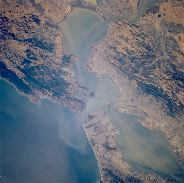 |
| STS064-110-089 San Francisco Bay and San Pablo Bay, California, U.S.A. September 1994 San Pablo Bay, the northern extension of larger San Francisco Bay, is featured in this near-vertical, synoptic photograph. The sediment pattern in the water suggests a westward flow from San Francisco Bay into the coastal waters of the Pacific Ocean. Visible are several bridges, including Golden Gate Bridge, that connect the cities surrounding the bay. The ruggedness of the major ridges, hills, and low mountains, many in a northwest-southeast alignment, contrasts with the urban areas. |
| Images: | All Available Images Low-Resolution 351k |
|
| Mission: | STS064 |
|
| Roll - Frame: | 110 - 89 |
|
| Geographical Name: | USA-CALIFORNIA |
|
| Features: | SAN FRANCISCO BAY AREA |
|
| Center Lat x Lon: | 37.5N x 122.5W |
|
| Film Exposure: | N | N=Normal exposure, U=Under exposed, O=Over exposed, F=out of Focus |
| Percentage of Cloud Cover-CLDP: | 0 |
|
| Camera:: | HB |
|
| Camera Tilt: | 40 | LO=Low Oblique, HO=High Oblique, NV=Near Vertical |
| Camera Focal Length: | 250 |
|
| Nadir to Photo Center Direction: | W | The direction from the nadir to the center point, N=North, S=South, E=East, W=West |
| Stereo?: | N | Y=Yes there is an adjacent picture of the same area, N=No there isn't |
| Orbit Number: | 98 |
|
| Date: | 19940915 | YYYYMMDD |
| Time: | 232807 | GMT HHMMSS |
| Nadir Lat: | 37.7N |
Latitude of suborbital point of spacecraft |
| Nadir Lon: | 120.7W |
Longitude of suborbital point of spacecraft |
| Sun Azimuth: | 247 | Clockwise angle in degrees from north to the sun measured at the nadir point |
| Space Craft Altitude: | 131 | nautical miles |
| Sun Elevation: | 31 | Angle in degrees between the horizon and the sun, measured at the nadir point |
| Land Views: | MOUNTAIN, FAULT |
|
| Water Views: | BAY, SEDIMENT |
|
| Atmosphere Views: | |
|
| Man Made Views: | URBAN AREA |
|
| City Views: | SAN FRANCISCO, BERKELEY |
|
Photo is not associated with any sequences | ||
| NASA Home Page |
JSC Home Page |
JSC Digital Image Collection |
Earth Science & Remote Sensing |
|
This service is provided by the International Space Station program and the JSC Earth Science & Remote Sensing Unit, ARES Division, Exploration Integration Science Directorate.

|