
Geographic Region: USA-CALIFORNIA
Feature: SAN FRANCISCO BAY AREA
|
Geographic Region: USA-CALIFORNIA Feature: SAN FRANCISCO BAY AREA |
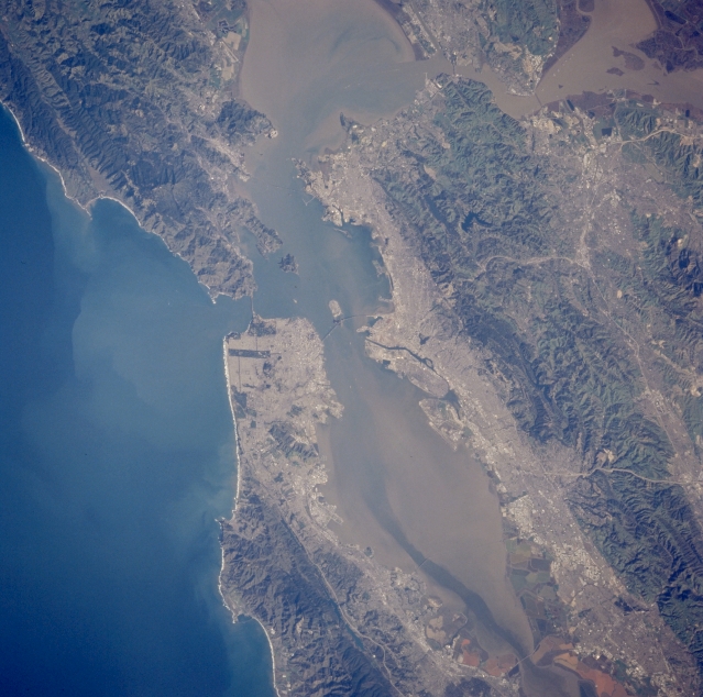 |
| STS062-098-156 San Francisco Bay, California, U.S.A. March 1994 Both urban areas and low, rugged mountains and ridges surrounding San Francisco are captured in this photograph. Two northwest-southeast-trending faults are discernible--Hayward Fault, bordering the urban area east of San Francisco Bay, and San Andreas Fault, crossing the mid-San Francisco Peninsula before dipping beneath the Pacific Ocean and surfacing again northwest of Golden Gate Bridge. Five major bridges connect Bay Area communities, and two highway arteries connect the densely populated Bay Area with the valley to the east and the communities of Walnut Creek, Concord, and Livermore. The colors along the southern edge of the bay are produced by the growth of algae in salt pans of varying degrees of salinity. Sediment plumes are visible in San Francisco Bay and the Pacific waters west of the Golden Gate Bridge. |
| Images: | All Available Images Low-Resolution 324k |
|
| Mission: | STS062 |
|
| Roll - Frame: | 98 - 156 |
|
| Geographical Name: | USA-CALIFORNIA |
|
| Features: | SAN FRANCISCO BAY AREA |
|
| Center Lat x Lon: | 37.5N x 122.5W |
|
| Film Exposure: | N | N=Normal exposure, U=Under exposed, O=Over exposed, F=out of Focus |
| Percentage of Cloud Cover-CLDP: | 0 |
|
| Camera:: | HB |
|
| Camera Tilt: | 34 | LO=Low Oblique, HO=High Oblique, NV=Near Vertical |
| Camera Focal Length: | 250 |
|
| Nadir to Photo Center Direction: | SW | The direction from the nadir to the center point, N=North, S=South, E=East, W=West |
| Stereo?: | Y | Y=Yes there is an adjacent picture of the same area, N=No there isn't |
| Orbit Number: | 130 |
|
| Date: | 19940312 | YYYYMMDD |
| Time: | 163231 | GMT HHMMSS |
| Nadir Lat: | 38.6N |
Latitude of suborbital point of spacecraft |
| Nadir Lon: | 121.1W |
Longitude of suborbital point of spacecraft |
| Sun Azimuth: | 116 | Clockwise angle in degrees from north to the sun measured at the nadir point |
| Space Craft Altitude: | 160 | nautical miles |
| Sun Elevation: | 24 | Angle in degrees between the horizon and the sun, measured at the nadir point |
| Land Views: | MOUNTAIN, FAULT |
|
| Water Views: | BAY, SEDIMENT |
|
| Atmosphere Views: | |
|
| Man Made Views: | URBAN AREA |
|
| City Views: | OAKLAND, SAN FRANCISCO, BERKELEY |
|
Photo is not associated with any sequences | ||
| NASA Home Page |
JSC Home Page |
JSC Digital Image Collection |
Earth Science & Remote Sensing |
|
This service is provided by the International Space Station program and the JSC Earth Science & Remote Sensing Unit, ARES Division, Exploration Integration Science Directorate.

|