
Geographic Region: USA-NEW MEXICO
Feature: WHITE SANDS, ANDRES MTS.
|
Geographic Region: USA-NEW MEXICO Feature: WHITE SANDS, ANDRES MTS. |
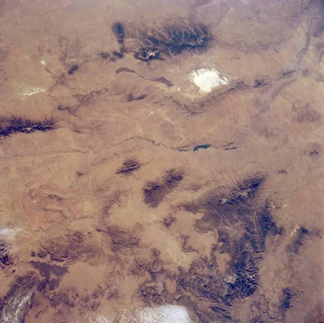 |
| STS062-087-130 Southwest New Mexico, New Mexico U.S.A. March 1994 This panoramic east-looking photograph of southwest New Mexico portrays the heavily forested cluster of eastern mountains (Sierra Blanca, Sacramento, and Capitan) and Gila National Forest (including the Gallo, Mogollon, and Tularosa Mountains and the Black Range) to the west. Various shades of brown indicate sparsely vegetated valleys in the mountainous region. Visible between these mountain ranges are the narrow, linear Rio Grande and its rift valley extending north-south with large, dark Elephant Butte Reservoir in its course; the San Andres Mountains to its east; the highly reflective White Sands gypsum desert; and the ribbon-shaped, dark lava flow. Visible north of White Sands are the dry lakes of Laguna del Perro, and to their west is the southern end of the forested Manzano Mountains. To the west, clouds and snowcapped mountain peaks are discernible. |
| Images: | All Available Images Low-Resolution 325k |
|
| Mission: | STS062 |
|
| Roll - Frame: | 87 - 130 |
|
| Geographical Name: | USA-NEW MEXICO |
|
| Features: | WHITE SANDS, ANDRES MTS. |
|
| Center Lat x Lon: | 33.0N x 106W |
|
| Film Exposure: | N | N=Normal exposure, U=Under exposed, O=Over exposed, F=out of Focus |
| Percentage of Cloud Cover-CLDP: | 5 |
|
| Camera:: | HB |
|
| Camera Tilt: | LO | LO=Low Oblique, HO=High Oblique, NV=Near Vertical |
| Camera Focal Length: | 40 |
|
| Nadir to Photo Center Direction: | The direction from the nadir to the center point, N=North, S=South, E=East, W=West |
|
| Stereo?: | N | Y=Yes there is an adjacent picture of the same area, N=No there isn't |
| Orbit Number: | |
|
| Date: | 199403__ | YYYYMMDD |
| Time: | GMT HHMMSS |
|
| Nadir Lat: | N |
Latitude of suborbital point of spacecraft |
| Nadir Lon: | E |
Longitude of suborbital point of spacecraft |
| Sun Azimuth: | Clockwise angle in degrees from north to the sun measured at the nadir point |
|
| Space Craft Altitude: | nautical miles |
|
| Sun Elevation: | Angle in degrees between the horizon and the sun, measured at the nadir point |
|
| Land Views: | MOUNTAIN, VALLEY |
|
| Water Views: | RIVER |
|
| Atmosphere Views: | |
|
| Man Made Views: | |
|
| City Views: | |
|
Photo is not associated with any sequences | ||
| NASA Home Page |
JSC Home Page |
JSC Digital Image Collection |
Earth Science & Remote Sensing |
|
This service is provided by the International Space Station program and the JSC Earth Science & Remote Sensing Unit, ARES Division, Exploration Integration Science Directorate.

|