
Geographic Region: USA-INDIANA
Feature: CINCINNATI AREA, OHIO R.
|
Geographic Region: USA-INDIANA Feature: CINCINNATI AREA, OHIO R. |
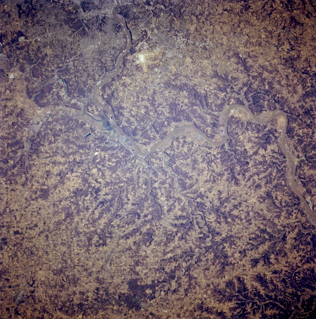 |
| STS062-081-007 Ohio River Valley, Kentucky, U.S.A. March 1994 Apparent are the incised floodplain of the Ohio River, the dark landscape of eroded stream valleys, and the lighter terrain of cultivated hilltops and ridgelines. Barely discernible are the faint outlines of Covington, Kentucky, and western Cincinnati, Ohio (bottom center), west of which is the confluence of the Great Miami River and the Ohio River and still farther west, the convergence of Kentucky, Indiana, and Ohio. Bright, highly reflective Cincinnati-Northern Kentucky International Airport west of Covington is visible (bottom center). |
| Images: | All Available Images Low-Resolution 417k |
|
| Mission: | STS062 |
|
| Roll - Frame: | 81 - 7 |
|
| Geographical Name: | USA-INDIANA |
|
| Features: | CINCINNATI AREA, OHIO R. |
|
| Center Lat x Lon: | 39.0N x 85W |
|
| Film Exposure: | N | N=Normal exposure, U=Under exposed, O=Over exposed, F=out of Focus |
| Percentage of Cloud Cover-CLDP: | 0 |
|
| Camera:: | HB |
|
| Camera Tilt: | 9 | LO=Low Oblique, HO=High Oblique, NV=Near Vertical |
| Camera Focal Length: | 250 |
|
| Nadir to Photo Center Direction: | E | The direction from the nadir to the center point, N=North, S=South, E=East, W=West |
| Stereo?: | N | Y=Yes there is an adjacent picture of the same area, N=No there isn't |
| Orbit Number: | 3 |
|
| Date: | 19940304 | YYYYMMDD |
| Time: | 170751 | GMT HHMMSS |
| Nadir Lat: | 39.1N |
Latitude of suborbital point of spacecraft |
| Nadir Lon: | 85.4W |
Longitude of suborbital point of spacecraft |
| Sun Azimuth: | 164 | Clockwise angle in degrees from north to the sun measured at the nadir point |
| Space Craft Altitude: | 161 | nautical miles |
| Sun Elevation: | 44 | Angle in degrees between the horizon and the sun, measured at the nadir point |
| Land Views: | FLOOD PLAIN |
|
| Water Views: | RIVER |
|
| Atmosphere Views: | |
|
| Man Made Views: | AIRPORT |
|
| City Views: | |
|
Photo is not associated with any sequences | ||
| NASA Home Page |
JSC Home Page |
JSC Digital Image Collection |
Earth Science & Remote Sensing |
|
This service is provided by the International Space Station program and the JSC Earth Science & Remote Sensing Unit, ARES Division, Exploration Integration Science Directorate.

|