Geographic Region: MADAGASCAR
Feature: SOUTHERN, CENTRAL AREAS
|
Geographic Region: MADAGASCAR Feature: SOUTHERN, CENTRAL AREAS |
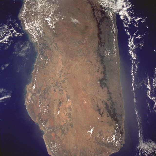 |
| STS061-098-005 Southern Madagascar December 1993 Almost two-thirds of Madagascar, the world's fourth largest island, is seen in this near-vertical, almost cloud-free photograph. The island is composed of relatively narrow coastal plains on both the east and west coasts, with a much larger central plateau that extends generally north-south for the entire length of the country. The dark north-south line that parallels the east coast shows the remaining 10 percent of the original lowland and mountain rain forests that exist on Madagascar. The major cause of the dramatic decrease in forests has been the slash-and-burn agriculture practiced by small-scale farmers. The future will determine if imposed conservation strategies will be effective in reversing this destructive practice. Because the east coast lies in the path of the rain-bearing southeast trade winds that blow off the Indian Ocean, it receives an annual average rainfall of more than 70 inches (180 centimeters). A rain-shadow effect is created by the low mountains along the east coast of Madagascar, as precipitation amounts decrease appreciably to the west. The southwestern corner of the island is classified as arid to semiarid. Major soil erosion problems are common throughout most of the island, particularly along the western edge of the country where many of the westward-flowing rivers carry large quantities of sediment into the bays and estuaries. |
| Images: | All Available Images Low-Resolution 119k |
|
| Mission: | STS061 |
|
| Roll - Frame: | 98 - 5 |
|
| Geographical Name: | MADAGASCAR |
|
| Features: | SOUTHERN, CENTRAL AREAS |
|
| Center Lat x Lon: | 21S x 47.0E |
|
| Film Exposure: | N | N=Normal exposure, U=Under exposed, O=Over exposed, F=out of Focus |
| Percentage of Cloud Cover-CLDP: | 10 |
|
| Camera:: | HB |
|
| Camera Tilt: | 23 | LO=Low Oblique, HO=High Oblique, NV=Near Vertical |
| Camera Focal Length: | 40 |
|
| Nadir to Photo Center Direction: | NE | The direction from the nadir to the center point, N=North, S=South, E=East, W=West |
| Stereo?: | N | Y=Yes there is an adjacent picture of the same area, N=No there isn't |
| Orbit Number: | 90 |
|
| Date: | 19931208 | YYYYMMDD |
| Time: | 083734 | GMT HHMMSS |
| Nadir Lat: | 22.8S |
Latitude of suborbital point of spacecraft |
| Nadir Lon: | 45.6E |
Longitude of suborbital point of spacecraft |
| Sun Azimuth: | 91 | Clockwise angle in degrees from north to the sun measured at the nadir point |
| Space Craft Altitude: | 320 | nautical miles |
| Sun Elevation: | 87 | Angle in degrees between the horizon and the sun, measured at the nadir point |
| Land Views: | ISLAND, MOUNTAIN, FOREST, PLATEAU, BASIN |
|
| Water Views: | OCEAN, CHANNEL, RIVER, DELTA |
|
| Atmosphere Views: | |
|
| Man Made Views: | DEFORESTATION |
|
| City Views: | |
|
Photo is not associated with any sequences | ||
| NASA Home Page |
JSC Home Page |
JSC Digital Image Collection |
Earth Science & Remote Sensing |
|
This service is provided by the International Space Station program and the JSC Earth Science & Remote Sensing Unit, ARES Division, Exploration Integration Science Directorate.

|