Geographic Region: YEMEN
Feature: HIJAZ MASSIF, HAWDRAMAT
|
Geographic Region: YEMEN Feature: HIJAZ MASSIF, HAWDRAMAT |
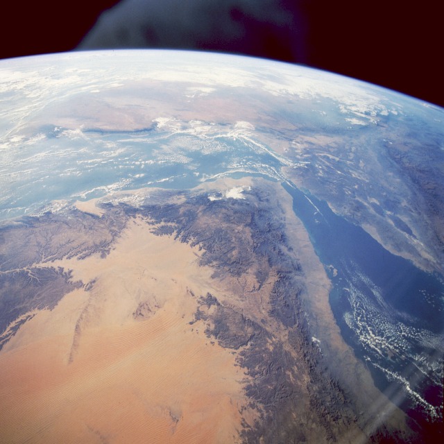 |
| STS061-079-024 Southwest Arabian Peninsula, Saudi Arabia, and Yemen December 1993 This south-southwest-looking, high-oblique photograph shows the southwestern Arabian Peninsula, the Gulf of Aden, the Red Sea, northern Somalia, the Afar Triangle, and the Great Rift Valley of Ethiopia. The southwestern Arabian Peninsula, most of which is in Yemen, has a narrow coastal plain (Tihamah) along the Red Sea about 20 to 50 miles (30 to 80 kilometers) wide, interior highlands, and mountains that descend to a great sandy desert. The coastal plain is hot and virtually rainless with high humidity, alluvium and talus carried down from the highlands, and little vegetation cover. The interior highlands, a section of the uplifted Arabian Plateau rising more than 12 000 feet (660 meters), annually receive an average of 20 inches (50 centimeters) of precipitation, most falling between the months of June and September. This area is the wettest part of the Arabian Peninsula with numerous wadis (valleys and/or watercourses); Wadi Hadhramaut (east of center) is the largest. The upper and middle highlands, Yemen's best farmlands, have alluvial soils and moisture from intermittent streams; the lower portions are uninhabited and extremely dry. The eastern and northern highlands, which are in the rain shadow, slope down into the great sandy expanse of the reddish southwestern Rub' al Khali Desert with parallel northeast-southwest trending sand dunes. West and southwest of the Arabian Peninsula and the Red Sea is the Danakil Depression, part of the Great African Rift Valley; south of the peninsula, scattered clouds cover portions of the Gulf of Aden and the coastal ranges of northern Somalia. |
| Images: | All Available Images Low-Resolution 105k |
|
| Mission: | STS061 |
|
| Roll - Frame: | 79 - 24 |
|
| Geographical Name: | YEMEN |
|
| Features: | HIJAZ MASSIF, HAWDRAMAT |
|
| Center Lat x Lon: | 14.0N x 44.5E |
|
| Film Exposure: | N | N=Normal exposure, U=Under exposed, O=Over exposed, F=out of Focus |
| Percentage of Cloud Cover-CLDP: | 30 |
|
| Camera:: | HB |
|
| Camera Tilt: | HO | LO=Low Oblique, HO=High Oblique, NV=Near Vertical |
| Camera Focal Length: | 40 |
|
| Nadir to Photo Center Direction: | S | The direction from the nadir to the center point, N=North, S=South, E=East, W=West |
| Stereo?: | Y | Y=Yes there is an adjacent picture of the same area, N=No there isn't |
| Orbit Number: | 28 |
|
| Date: | 19931204 | YYYYMMDD |
| Time: | 044257 | GMT HHMMSS |
| Nadir Lat: | 19.1N |
Latitude of suborbital point of spacecraft |
| Nadir Lon: | 45.2E |
Longitude of suborbital point of spacecraft |
| Sun Azimuth: | 122 | Clockwise angle in degrees from north to the sun measured at the nadir point |
| Space Craft Altitude: | 315 | nautical miles |
| Sun Elevation: | 17 | Angle in degrees between the horizon and the sun, measured at the nadir point |
| Land Views: | COAST, DESERT, DUNE, FAULT, PENINSULA, PLATEAU, VALLEY, MOUNTAIN, VOLCANO |
|
| Water Views: | BAY, GULF, SEA |
|
| Atmosphere Views: | |
|
| Man Made Views: | |
|
| City Views: | |
|
Photo is not associated with any sequences | ||
| NASA Home Page |
JSC Home Page |
JSC Digital Image Collection |
Earth Science & Remote Sensing |
|
This service is provided by the International Space Station program and the JSC Earth Science & Remote Sensing Unit, ARES Division, Exploration Integration Science Directorate.

|