Geographic Region: VENEZUELA
Feature: COAST,PUERO LA CRUZ AREA
|
Geographic Region: VENEZUELA Feature: COAST,PUERO LA CRUZ AREA |
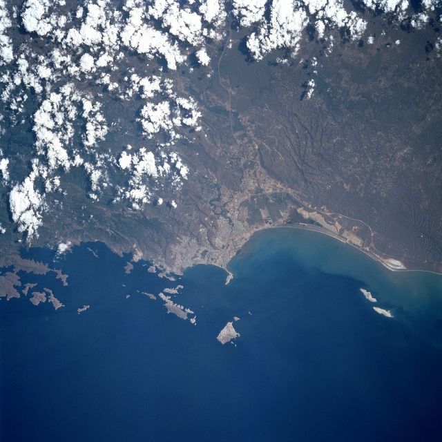 |
| STS060-084-076 Mochima National Park, Venezuela February 1994 Mochima National Park is both a marine and land based park in Anzoategui State. The offshore islands in this photograph are part of the park. The Caribbean coast of Venezuela in this region is scrub thornbrush. The Turimquire Mountains come right down to the sea and form high cliffs. The Island in the center of the photograph is over 1300 feet high. Puerto La Cruz has a population of over 800,000 and is located on the bay in the center of the view. Barcelona, the capital of Anzoategui State is to the right of Puerto La Cruz. The road that bisects the photograph leads inland to the Orinoco basin on the far side of the mountains. |
| Images: | All Available Images Low-Resolution 341k |
|
| Mission: | STS060 |
|
| Roll - Frame: | 84 - 76 |
|
| Geographical Name: | VENEZUELA |
|
| Features: | COAST,PUERO LA CRUZ AREA |
|
| Center Lat x Lon: | 10.0N x 65W |
|
| Film Exposure: | N | N=Normal exposure, U=Under exposed, O=Over exposed, F=out of Focus |
| Percentage of Cloud Cover-CLDP: | 20 |
|
| Camera:: | HB |
|
| Camera Tilt: | LO | LO=Low Oblique, HO=High Oblique, NV=Near Vertical |
| Camera Focal Length: | 250 |
|
| Nadir to Photo Center Direction: | The direction from the nadir to the center point, N=North, S=South, E=East, W=West |
|
| Stereo?: | N | Y=Yes there is an adjacent picture of the same area, N=No there isn't |
| Orbit Number: | |
|
| Date: | 199402__ | YYYYMMDD |
| Time: | GMT HHMMSS |
|
| Nadir Lat: | N |
Latitude of suborbital point of spacecraft |
| Nadir Lon: | E |
Longitude of suborbital point of spacecraft |
| Sun Azimuth: | Clockwise angle in degrees from north to the sun measured at the nadir point |
|
| Space Craft Altitude: | nautical miles |
|
| Sun Elevation: | Angle in degrees between the horizon and the sun, measured at the nadir point |
|
| Land Views: | COAST, MOUNTAIN, FOREST |
|
| Water Views: | RIVER, SEDIMENT, SEA |
|
| Atmosphere Views: | |
|
| Man Made Views: | URBAN AREA |
|
| City Views: | BARCELONA |
|
Photo is not associated with any sequences | ||
| NASA Home Page |
JSC Home Page |
JSC Digital Image Collection |
Earth Science & Remote Sensing |
|
This service is provided by the International Space Station program and the JSC Earth Science & Remote Sensing Unit, ARES Division, Exploration Integration Science Directorate.

|