Geographic Region: HAITI
Feature: GULF,ISLAND OF GONAVE
|
Geographic Region: HAITI Feature: GULF,ISLAND OF GONAVE |
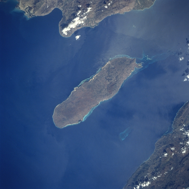 |
| STS060-84-56 Gonave Island, Haiti February 1994 Located to the west-northwest of Port Au-Prince, Haiti in the Gulf of Gonave, the reef- fringed island of Gonave can be seen in this near-nadir looking view. Made up of mostly limestone, the island of Gonave is 37 miles (60 km) long and 9 miles (15 km) wide and covers an area of 287 sq. miles (743 sq. km). The island is mostly barren and hilly with the highest point reaching 984 feet (300 meters). The rugged, barren, dry landscape prevents the cultivation of the land for agriculture and human population on the island is scarce. The island was once used as a base for pirates. |
| Images: | All Available Images Low-Resolution 279k |
|
| Mission: | STS060 |
|
| Roll - Frame: | 84 - 56 |
|
| Geographical Name: | HAITI |
|
| Features: | GULF,ISLAND OF GONAVE |
|
| Center Lat x Lon: | 19.0N x 73W |
|
| Film Exposure: | N | N=Normal exposure, U=Under exposed, O=Over exposed, F=out of Focus |
| Percentage of Cloud Cover-CLDP: | 5 |
|
| Camera:: | HB |
|
| Camera Tilt: | LO | LO=Low Oblique, HO=High Oblique, NV=Near Vertical |
| Camera Focal Length: | 250 |
|
| Nadir to Photo Center Direction: | The direction from the nadir to the center point, N=North, S=South, E=East, W=West |
|
| Stereo?: | N | Y=Yes there is an adjacent picture of the same area, N=No there isn't |
| Orbit Number: | |
|
| Date: | 199402__ | YYYYMMDD |
| Time: | GMT HHMMSS |
|
| Nadir Lat: | N |
Latitude of suborbital point of spacecraft |
| Nadir Lon: | E |
Longitude of suborbital point of spacecraft |
| Sun Azimuth: | Clockwise angle in degrees from north to the sun measured at the nadir point |
|
| Space Craft Altitude: | nautical miles |
|
| Sun Elevation: | Angle in degrees between the horizon and the sun, measured at the nadir point |
|
| Land Views: | ISLAND, HILL |
|
| Water Views: | GULF, REEF |
|
| Atmosphere Views: | |
|
| Man Made Views: | |
|
| City Views: | |
|
Photo is not associated with any sequences | ||
| NASA Home Page |
JSC Home Page |
JSC Digital Image Collection |
Earth Science & Remote Sensing |
|
This service is provided by the International Space Station program and the JSC Earth Science & Remote Sensing Unit, ARES Division, Exploration Integration Science Directorate.

|