
Geographic Region: USA-NEW MEXICO
Feature: SAN JUAN R., FARMINGTON
|
Geographic Region: USA-NEW MEXICO Feature: SAN JUAN R., FARMINGTON |
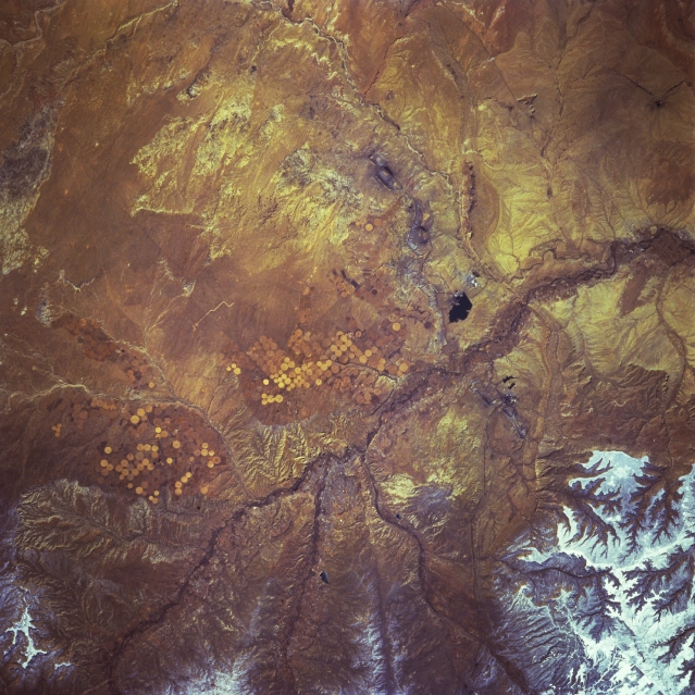 |
| STS060-083-009 Farmington, New Mexico, U.S.A. February 1994 Farmington (not discernible) in extreme northwest New Mexico lies near the junction of the San Juan River, the main stream seen traversing this arid landscape, and several of its tributaries. Visible south of the river are center-pivot irrigation fields east and west of Farmington and a dark, irregular reservoir west of the city. Snow cover is discernible in the higher elevations to the northwest. |
| Images: | All Available Images Low-Resolution 374k |
|
| Mission: | STS060 |
|
| Roll - Frame: | 83 - 9 |
|
| Geographical Name: | USA-NEW MEXICO |
|
| Features: | SAN JUAN R., FARMINGTON |
|
| Center Lat x Lon: | 36.5N x 108.5W |
|
| Film Exposure: | N | N=Normal exposure, U=Under exposed, O=Over exposed, F=out of Focus |
| Percentage of Cloud Cover-CLDP: | 0 |
|
| Camera:: | HB |
|
| Camera Tilt: | 11 | LO=Low Oblique, HO=High Oblique, NV=Near Vertical |
| Camera Focal Length: | 250 |
|
| Nadir to Photo Center Direction: | NW | The direction from the nadir to the center point, N=North, S=South, E=East, W=West |
| Stereo?: | N | Y=Yes there is an adjacent picture of the same area, N=No there isn't |
| Orbit Number: | 116 |
|
| Date: | 19940210 | YYYYMMDD |
| Time: | 200928 | GMT HHMMSS |
| Nadir Lat: | 36.1N |
Latitude of suborbital point of spacecraft |
| Nadir Lon: | 108W |
Longitude of suborbital point of spacecraft |
| Sun Azimuth: | 193 | Clockwise angle in degrees from north to the sun measured at the nadir point |
| Space Craft Altitude: | 191 | nautical miles |
| Sun Elevation: | 39 | Angle in degrees between the horizon and the sun, measured at the nadir point |
| Land Views: | PLATEAU |
|
| Water Views: | RIVER |
|
| Atmosphere Views: | |
|
| Man Made Views: | PIVOT IRRIGATION |
|
| City Views: | |
|
Photo is not associated with any sequences | ||
| NASA Home Page |
JSC Home Page |
JSC Digital Image Collection |
Earth Science & Remote Sensing |
|
This service is provided by the International Space Station program and the JSC Earth Science & Remote Sensing Unit, ARES Division, Exploration Integration Science Directorate.

|