
Geographic Region: USA-UTAH
Feature: LAKE POWELL, NAVAJO MT.
|
Geographic Region: USA-UTAH Feature: LAKE POWELL, NAVAJO MT. |
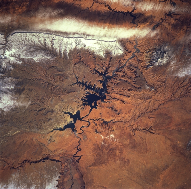 |
| STS060-083-001 Lake Powell and Kaiparowits Plateau, Utah and Arizona, U.S.A. February 1994 The southern portion of Lake Powell in Glen Canyon National Recreation Area is featured in this northeast-looking, low-oblique photograph. Rugged, snow-covered Navajo Mountain (near the upper right corner of the photograph) lies east of Lake Powell. Lake Powell covers approximately 252 square miles (653 square kilometers) and is used primarily for recreation and irrigation. Apparent are the Paria Plateau escarpment in northern Arizona (bottom left) and the Kaiparowits Plateau discernible west of the lake. |
| Images: | All Available Images Low-Resolution 372k |
|
| Mission: | STS060 |
|
| Roll - Frame: | 83 - 1 |
|
| Geographical Name: | USA-UTAH |
|
| Features: | LAKE POWELL, NAVAJO MT. |
|
| Center Lat x Lon: | 37.0N x 111W |
|
| Film Exposure: | N | N=Normal exposure, U=Under exposed, O=Over exposed, F=out of Focus |
| Percentage of Cloud Cover-CLDP: | 5 |
|
| Camera:: | HB |
|
| Camera Tilt: | 28 | LO=Low Oblique, HO=High Oblique, NV=Near Vertical |
| Camera Focal Length: | 250 |
|
| Nadir to Photo Center Direction: | S | The direction from the nadir to the center point, N=North, S=South, E=East, W=West |
| Stereo?: | Y | Y=Yes there is an adjacent picture of the same area, N=No there isn't |
| Orbit Number: | 116 |
|
| Date: | 19940210 | YYYYMMDD |
| Time: | 200833 | GMT HHMMSS |
| Nadir Lat: | 38.7N |
Latitude of suborbital point of spacecraft |
| Nadir Lon: | 110.9W |
Longitude of suborbital point of spacecraft |
| Sun Azimuth: | 189 | Clockwise angle in degrees from north to the sun measured at the nadir point |
| Space Craft Altitude: | 191 | nautical miles |
| Sun Elevation: | 37 | Angle in degrees between the horizon and the sun, measured at the nadir point |
| Land Views: | PLATEAU, ESCARPMENT |
|
| Water Views: | LAKE |
|
| Atmosphere Views: | |
|
| Man Made Views: | |
|
| City Views: | |
|
Photo is not associated with any sequences | ||
| NASA Home Page |
JSC Home Page |
JSC Digital Image Collection |
Earth Science & Remote Sensing |
|
This service is provided by the International Space Station program and the JSC Earth Science & Remote Sensing Unit, ARES Division, Exploration Integration Science Directorate.

|