
Geographic Region: USA-CALIFORNIA
Feature: KLAMATH MOUNTAINS & RIV.
|
Geographic Region: USA-CALIFORNIA Feature: KLAMATH MOUNTAINS & RIV. |
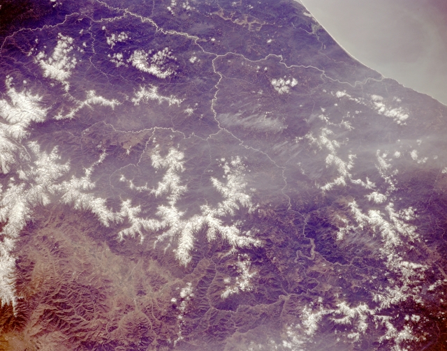 |
| STS059-L09-150 Klamath Mountains and Klamath River, California, U.S.A. April 1994 The rugged, snow-covered Klamath Mountains, part of the Coast Range, are featured in this southwest-looking, low-oblique photograph. The Klamath Mountains have numerous peaks exceeding 7000 feet (2135 meters). The Klamath River is visible winding south and then northwest, following the Hoopa Valley Indian Reservation, and emptying into the Pacific Ocean (top right of photograph) south of Crescent City, California. |
| Images: | All Available Images Low-Resolution 296k |
|
| Mission: | STS059 |
|
| Roll - Frame: | L09 - 150 |
|
| Geographical Name: | USA-CALIFORNIA |
|
| Features: | KLAMATH MOUNTAINS & RIV. |
|
| Center Lat x Lon: | 41.5N x 123.5W |
|
| Film Exposure: | U | N=Normal exposure, U=Under exposed, O=Over exposed, F=out of Focus |
| Percentage of Cloud Cover-CLDP: | 5 |
|
| Camera:: | LH |
|
| Camera Tilt: | 38 | LO=Low Oblique, HO=High Oblique, NV=Near Vertical |
| Camera Focal Length: | 250 |
|
| Nadir to Photo Center Direction: | SW | The direction from the nadir to the center point, N=North, S=South, E=East, W=West |
| Stereo?: | N | Y=Yes there is an adjacent picture of the same area, N=No there isn't |
| Orbit Number: | 24 |
|
| Date: | 19940410 | YYYYMMDD |
| Time: | 213625 | GMT HHMMSS |
| Nadir Lat: | 42.6N |
Latitude of suborbital point of spacecraft |
| Nadir Lon: | 122.4W |
Longitude of suborbital point of spacecraft |
| Sun Azimuth: | 215 | Clockwise angle in degrees from north to the sun measured at the nadir point |
| Space Craft Altitude: | 119 | nautical miles |
| Sun Elevation: | 51 | Angle in degrees between the horizon and the sun, measured at the nadir point |
| Land Views: | MOUNTAIN, FAULT, FOREST |
|
| Water Views: | RIVER |
|
| Atmosphere Views: | |
|
| Man Made Views: | |
|
| City Views: | |
|
Photo is not associated with any sequences | ||
| NASA Home Page |
JSC Home Page |
JSC Digital Image Collection |
Earth Science & Remote Sensing |
|
This service is provided by the International Space Station program and the JSC Earth Science & Remote Sensing Unit, ARES Division, Exploration Integration Science Directorate.

|