Geographic Region: AUSTRALIA-Q
Feature: BARKLY TABLELAND, RIVER
|
Geographic Region: AUSTRALIA-Q Feature: BARKLY TABLELAND, RIVER |
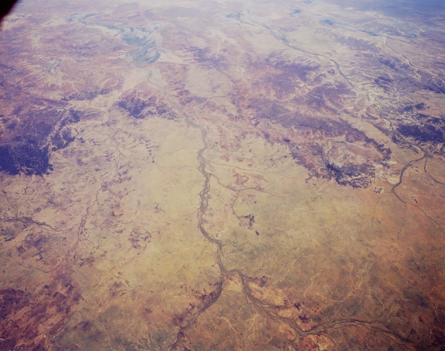 |
| STS059-L06-010 Thompson River Basin, Queensland, Australia April 1994 Two large ephemeral drainage systems (Thomson River at center and Diamantina River at upper right) can be traced across the semiarid central Queensland landscape in this southwest-looking view. Both rivers drain southwestward in this section of the Great Artesian Basin. The Outback (bottom half of image) is made up of gently rolling hills but mainly flat prairie grasslands. Farther southwest, the landscape is dramatically eroded, almost giving the upper half of the picture a three dimensional quality. The confluence of the Thompson River and Aramac Creek is visible near the bottom center of the image. Darker areas near the top of the image are river floodplains that can broaden considerably and become ephemeral lagoons during wet periods. The Barcoo River, another ephemeral drainage basin, can also be seen parallel to and east of the Thomson River. |
| Images: | All Available Images Low-Resolution 274k |
|
| Mission: | STS059 |
|
| Roll - Frame: | L06 - 10 |
|
| Geographical Name: | AUSTRALIA-Q |
|
| Features: | BARKLY TABLELAND, RIVER |
|
| Center Lat x Lon: | 23.5S x 144.0E |
|
| Film Exposure: | N | N=Normal exposure, U=Under exposed, O=Over exposed, F=out of Focus |
| Percentage of Cloud Cover-CLDP: | 0 |
|
| Camera:: | LH |
|
| Camera Tilt: | 44 | LO=Low Oblique, HO=High Oblique, NV=Near Vertical |
| Camera Focal Length: | 90 |
|
| Nadir to Photo Center Direction: | SW | The direction from the nadir to the center point, N=North, S=South, E=East, W=West |
| Stereo?: | Y | Y=Yes there is an adjacent picture of the same area, N=No there isn't |
| Orbit Number: | 94 |
|
| Date: | 19940415 | YYYYMMDD |
| Time: | 053141 | GMT HHMMSS |
| Nadir Lat: | 22.2S |
Latitude of suborbital point of spacecraft |
| Nadir Lon: | 145.3E |
Longitude of suborbital point of spacecraft |
| Sun Azimuth: | 299 | Clockwise angle in degrees from north to the sun measured at the nadir point |
| Space Craft Altitude: | 116 | nautical miles |
| Sun Elevation: | 33 | Angle in degrees between the horizon and the sun, measured at the nadir point |
| Land Views: | BASIN, DESERT, FLOOD PLAIN |
|
| Water Views: | RIVER |
|
| Atmosphere Views: | |
|
| Man Made Views: | |
|
| City Views: | |
|
Photo is not associated with any sequences | ||
| NASA Home Page |
JSC Home Page |
JSC Digital Image Collection |
Earth Science & Remote Sensing |
|
This service is provided by the International Space Station program and the JSC Earth Science & Remote Sensing Unit, ARES Division, Exploration Integration Science Directorate.

|