Geographic Region: SWEDEN
Feature: NORTH SEA, BALTIC SEA
|
Geographic Region: SWEDEN Feature: NORTH SEA, BALTIC SEA |
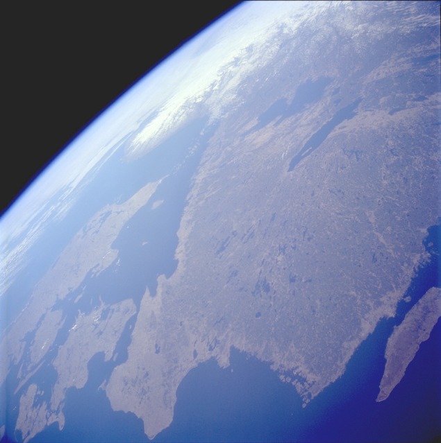 |
| STS059-223-065 Southern Sweden April 1994 Southern Sweden, with its plethora of lakes, is visible in this west-looking, high-oblique photograph. The lakes were created when the continental glaciers scoured this area and then receded, allowing the countless depressions to fill with water. In addition to numerous smaller lakes that are generally aligned in a north-south orientation, two large lakes--larger Lake Vänern and Lake Vättern--can be seen toward the northern edge of the photograph. The dark green area inland from the coast is forested lands. A small part of the Baltic Sea is pictured off the southeast coast of Sweden, and the Skagerrak and Kattegat, the waterway entrance into the Baltic Sea, are shown off the southwest coast of Sweden. Although no specific details can be ascertained at this scale, the four main landforms of Denmark (viewing west to east)--a peninsula (Jylland) and three islands (Fyn, Sjelland, and Lolland)--can be seen along the southern edge of the photograph. |
| Images: | All Available Images Low-Resolution 77k |
|
| Mission: | STS059 |
|
| Roll - Frame: | 223 - 65 |
|
| Geographical Name: | SWEDEN |
|
| Features: | NORTH SEA, BALTIC SEA |
|
| Center Lat x Lon: | 56.0N x 17.0E |
|
| Film Exposure: | N | N=Normal exposure, U=Under exposed, O=Over exposed, F=out of Focus |
| Percentage of Cloud Cover-CLDP: | 10 |
|
| Camera:: | HB |
|
| Camera Tilt: | HO | LO=Low Oblique, HO=High Oblique, NV=Near Vertical |
| Camera Focal Length: | 40 |
|
| Nadir to Photo Center Direction: | W | The direction from the nadir to the center point, N=North, S=South, E=East, W=West |
| Stereo?: | N | Y=Yes there is an adjacent picture of the same area, N=No there isn't |
| Orbit Number: | 144 |
|
| Date: | 19940418 | YYYYMMDD |
| Time: | 065923 | GMT HHMMSS |
| Nadir Lat: | 56.0N |
Latitude of suborbital point of spacecraft |
| Nadir Lon: | 17.1E |
Longitude of suborbital point of spacecraft |
| Sun Azimuth: | 111 | Clockwise angle in degrees from north to the sun measured at the nadir point |
| Space Craft Altitude: | 112 | nautical miles |
| Sun Elevation: | 27 | Angle in degrees between the horizon and the sun, measured at the nadir point |
| Land Views: | FOREST |
|
| Water Views: | LAKE, STRAIT |
|
| Atmosphere Views: | |
|
| Man Made Views: | |
|
| City Views: | |
|
Photo is not associated with any sequences | ||
| NASA Home Page |
JSC Home Page |
JSC Digital Image Collection |
Earth Science & Remote Sensing |
|
This service is provided by the International Space Station program and the JSC Earth Science & Remote Sensing Unit, ARES Division, Exploration Integration Science Directorate.

|