Geographic Region: CANADA-NS
Feature: SABLE ISLAND
|
Geographic Region: CANADA-NS Feature: SABLE ISLAND |
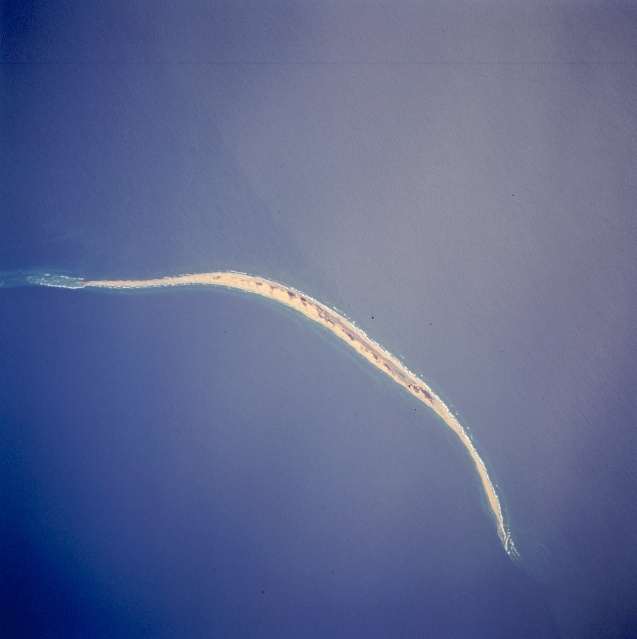 |
| STS059-216-079 Sable Island, Nova Scotia, Canada April 1994 Sable Island is a low sandy island approximately 25 miles (40 km) long and 1 mile (1.5 km) wide in the Atlantic Ocean. Located 115 miles (180 km) southeast of Cape Canso, Nova Scotia, the island is the exposed part of a sand shoal that extends northeast/southwest for more than 100 miles (160 km). Sable Island, known as the "graveyard of the Atlantic Ocean," has been a major hazard to navigation. The island is also noted as a breeding ground for seals, which are protected by the Canadian government. The island helps to mark the western edge of the northeasterly flowing warm waters of the Gulf Stream. |
| Images: | All Available Images Low-Resolution 238k |
|
| Mission: | STS059 |
|
| Roll - Frame: | 216 - 79 |
|
| Geographical Name: | CANADA-NS |
|
| Features: | SABLE ISLAND |
|
| Center Lat x Lon: | 44.0N x 60W |
|
| Film Exposure: | N | N=Normal exposure, U=Under exposed, O=Over exposed, F=out of Focus |
| Percentage of Cloud Cover-CLDP: | 0 |
|
| Camera:: | HB |
|
| Camera Tilt: | 18 | LO=Low Oblique, HO=High Oblique, NV=Near Vertical |
| Camera Focal Length: | 250 |
|
| Nadir to Photo Center Direction: | S | The direction from the nadir to the center point, N=North, S=South, E=East, W=West |
| Stereo?: | N | Y=Yes there is an adjacent picture of the same area, N=No there isn't |
| Orbit Number: | 53 |
|
| Date: | 19940412 | YYYYMMDD |
| Time: | 163149 | GMT HHMMSS |
| Nadir Lat: | 44.6N |
Latitude of suborbital point of spacecraft |
| Nadir Lon: | 59.8W |
Longitude of suborbital point of spacecraft |
| Sun Azimuth: | 193 | Clockwise angle in degrees from north to the sun measured at the nadir point |
| Space Craft Altitude: | 117 | nautical miles |
| Sun Elevation: | 54 | Angle in degrees between the horizon and the sun, measured at the nadir point |
| Land Views: | ISLAND |
|
| Water Views: | OCEAN |
|
| Atmosphere Views: | |
|
| Man Made Views: | |
|
| City Views: | |
|
Photo is not associated with any sequences | ||
| NASA Home Page |
JSC Home Page |
JSC Digital Image Collection |
Earth Science & Remote Sensing |
|
This service is provided by the International Space Station program and the JSC Earth Science & Remote Sensing Unit, ARES Division, Exploration Integration Science Directorate.

|