
Geographic Region: USA-NORTH CAROLINA
Feature: ABLEMAR & PAMLICO SOUNDS
|
Geographic Region: USA-NORTH CAROLINA Feature: ABLEMAR & PAMLICO SOUNDS |
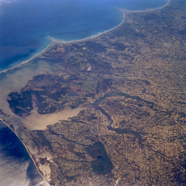 |
| STS059-208-068 Pamlico Sound Area, North Carolina, U.S.A. April 1994 A large section of the coastal plains immediately west of Cape Hatteras ( just off the picture, center left) is visible in this low oblique, southerly view. Most of Pamlico Sound, the large body of water that is protected by the linear barrier islands that extend along most of the North Carolina coastline, can be seen along the left side of the picture. The two easily identified capes, Lookout and Fear, are the V-shaped promontories that extend seaward into the Atlantic Ocean (near top of picture). The floodplains (dark green linear features near center of image) of the Chowan and Roanoke Rivers can also be traced across the landscape as they both empty into Albemarle Sound. Albemarle Sound can be identified as the light colored feature caused by the suns reflection off of the surface of the water (known as sunglint or sun glitter). The uniformly, dark rectangular feature is the densely wooded Great Dismal Swamp (bottom center). |
| Images: | All Available Images Low-Resolution 378k |
|
| Mission: | STS059 |
|
| Roll - Frame: | 208 - 68 |
|
| Geographical Name: | USA-NORTH CAROLINA |
|
| Features: | ABLEMAR & PAMLICO SOUNDS |
|
| Center Lat x Lon: | 36.0N x 77W |
|
| Film Exposure: | N | N=Normal exposure, U=Under exposed, O=Over exposed, F=out of Focus |
| Percentage of Cloud Cover-CLDP: | 0 |
|
| Camera:: | HB |
|
| Camera Tilt: | 54 | LO=Low Oblique, HO=High Oblique, NV=Near Vertical |
| Camera Focal Length: | 100 |
|
| Nadir to Photo Center Direction: | SW | The direction from the nadir to the center point, N=North, S=South, E=East, W=West |
| Stereo?: | N | Y=Yes there is an adjacent picture of the same area, N=No there isn't |
| Orbit Number: | 86 |
|
| Date: | 19940414 | YYYYMMDD |
| Time: | 172340 | GMT HHMMSS |
| Nadir Lat: | 38.3N |
Latitude of suborbital point of spacecraft |
| Nadir Lon: | 75.7W |
Longitude of suborbital point of spacecraft |
| Sun Azimuth: | 191 | Clockwise angle in degrees from north to the sun measured at the nadir point |
| Space Craft Altitude: | 115 | nautical miles |
| Sun Elevation: | 61 | Angle in degrees between the horizon and the sun, measured at the nadir point |
| Land Views: | CAPE, PLAIN, ISLAND |
|
| Water Views: | ESTUARY, OCEAN, RIVER, SWAMP |
|
| Atmosphere Views: | |
|
| Man Made Views: | |
|
| City Views: | |
|
Photo is not associated with any sequences | ||
| NASA Home Page |
JSC Home Page |
JSC Digital Image Collection |
Earth Science & Remote Sensing |
|
This service is provided by the International Space Station program and the JSC Earth Science & Remote Sensing Unit, ARES Division, Exploration Integration Science Directorate.

|