
Geographic Region: USA-MARYLAND
Feature: HAVRE DE GRACE AREA
|
Geographic Region: USA-MARYLAND Feature: HAVRE DE GRACE AREA |
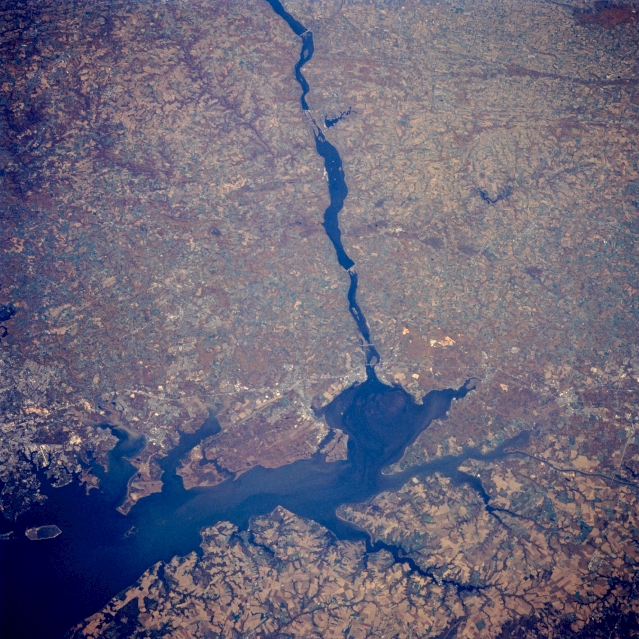 |
| STS058-088-094 Chesapeake Bay, Susquehanna River, Maryland, U.S.A. October 1993 The Susquehanna River enters the scene at the top center of the image and flows generally southeastward to Chesapeake Bay in this northwest-looking low-oblique view. Part of the Delmarva Peninsula covers the bottom fourth of the image. The Susquehanna River enters Chesapeake Bay near Havre de Grace, Maryland (light area west of the junction). Chesapeake Bay is the drowned lower course of the river. The area just to the southwest of the Susquehanna River entering the bay, is the Aberdeen Proving Ground and the Edgewood Arsenal. The northern portions of the city of Baltimore are visible along the left edge of the image midway between the center left and bottom left. The gently-rolling terrain inland from the bay gives way to the more hilly terrain of the eastern Appalachians in the upper third of the image. |
| Images: | All Available Images Low-Resolution 401k |
|
| Mission: | STS058 |
|
| Roll - Frame: | 88 - 94 |
|
| Geographical Name: | USA-MARYLAND |
|
| Features: | HAVRE DE GRACE AREA |
|
| Center Lat x Lon: | 40.0N x 76W |
|
| Film Exposure: | N | N=Normal exposure, U=Under exposed, O=Over exposed, F=out of Focus |
| Percentage of Cloud Cover-CLDP: | 0 |
|
| Camera:: | HB |
|
| Camera Tilt: | 37 | LO=Low Oblique, HO=High Oblique, NV=Near Vertical |
| Camera Focal Length: | 250 |
|
| Nadir to Photo Center Direction: | N | The direction from the nadir to the center point, N=North, S=South, E=East, W=West |
| Stereo?: | Y | Y=Yes there is an adjacent picture of the same area, N=No there isn't |
| Orbit Number: | 66 |
|
| Date: | 19931022 | YYYYMMDD |
| Time: | 164640 | GMT HHMMSS |
| Nadir Lat: | 38.1N |
Latitude of suborbital point of spacecraft |
| Nadir Lon: | 75.5W |
Longitude of suborbital point of spacecraft |
| Sun Azimuth: | 180 | Clockwise angle in degrees from north to the sun measured at the nadir point |
| Space Craft Altitude: | 155 | nautical miles |
| Sun Elevation: | 41 | Angle in degrees between the horizon and the sun, measured at the nadir point |
| Land Views: | PLAIN, FOREST |
|
| Water Views: | BAY, ESTUARY, RIVER |
|
| Atmosphere Views: | |
|
| Man Made Views: | AGRICULTURE |
|
| City Views: | |
|
Photo is not associated with any sequences | ||
| NASA Home Page |
JSC Home Page |
JSC Digital Image Collection |
Earth Science & Remote Sensing |
|
This service is provided by the International Space Station program and the JSC Earth Science & Remote Sensing Unit, ARES Division, Exploration Integration Science Directorate.

|