
Geographic Region: USA-MARYLAND
Feature: BALTIMORE
|
Geographic Region: USA-MARYLAND Feature: BALTIMORE |
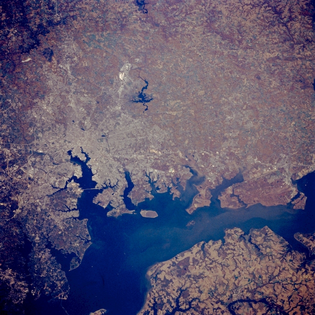 |
| STS058-088-093 Chesapeake Bay, Baltimore, Maryland, U.S.A. October 1993 The gently rolling-forested terrain around the city of Baltimore is visible in this northwest-looking low oblique view. Chesapeake Bay, an estuary of the Susquehanna River and the largest estuary in the United States, can be seen covering a good portion of the bottom half of the image. A small portion of the Delmarva Peninsula is discernible at the bottom right of the image. The city of Baltimore is situated on the Patapsco River estuary, an arm of Chesapeake Bay. Baltimore is a port of entry, a commercial and industrial center, and a great seaport with extensive anchorages, docks and storage facilities. Large amounts of coal, grain, iron, steel, and copper products are exported from Baltimore's ports. It is here, during the War of 1812, that Francis Scott Key wrote the Star-Spangled Banner, the United States' National Anthem. Baltimore is also the home of John Hopkins University, a major medical and health center in the United States. The Loch Raven Reservoir is visible to the north and west of Baltimore. Liberty Lake can be seen in the upper left corner of the image. |
| Images: | All Available Images Low-Resolution 397k |
|
| Mission: | STS058 |
|
| Roll - Frame: | 88 - 93 |
|
| Geographical Name: | USA-MARYLAND |
|
| Features: | BALTIMORE |
|
| Center Lat x Lon: | 39.5N x 76.5W |
|
| Film Exposure: | N | N=Normal exposure, U=Under exposed, O=Over exposed, F=out of Focus |
| Percentage of Cloud Cover-CLDP: | 0 |
|
| Camera:: | HB |
|
| Camera Tilt: | 29 | LO=Low Oblique, HO=High Oblique, NV=Near Vertical |
| Camera Focal Length: | 250 |
|
| Nadir to Photo Center Direction: | N | The direction from the nadir to the center point, N=North, S=South, E=East, W=West |
| Stereo?: | Y | Y=Yes there is an adjacent picture of the same area, N=No there isn't |
| Orbit Number: | 66 |
|
| Date: | 19931022 | YYYYMMDD |
| Time: | 164635 | GMT HHMMSS |
| Nadir Lat: | 38.2N |
Latitude of suborbital point of spacecraft |
| Nadir Lon: | 75.9W |
Longitude of suborbital point of spacecraft |
| Sun Azimuth: | 179 | Clockwise angle in degrees from north to the sun measured at the nadir point |
| Space Craft Altitude: | 155 | nautical miles |
| Sun Elevation: | 41 | Angle in degrees between the horizon and the sun, measured at the nadir point |
| Land Views: | PLAIN, FOREST |
|
| Water Views: | BAY, ESTUARY |
|
| Atmosphere Views: | |
|
| Man Made Views: | URBAN AREA |
|
| City Views: | BALTIMORE |
|
Photo is not associated with any sequences | ||
| NASA Home Page |
JSC Home Page |
JSC Digital Image Collection |
Earth Science & Remote Sensing |
|
This service is provided by the International Space Station program and the JSC Earth Science & Remote Sensing Unit, ARES Division, Exploration Integration Science Directorate.

|