Geographic Region: AUSTRALIA-WA
Feature: FITZROY RIVER, AIRPORT
|
Geographic Region: AUSTRALIA-WA Feature: FITZROY RIVER, AIRPORT |
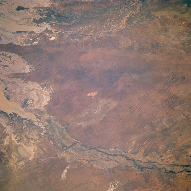 |
| STS056-96-047 Fitzroy River, Western Australia, Australia April 1993 The Fitzroy River (bottom of image) and the May and Meda Rivers (top of picture) drain northward into the southern end of King Sound (left side of image) along the northern coast of Western Australia. A complex array of dynamic coastal features in King Sound, including sandy sediment and muddy tidal flats, show up as brownish-looking features. There are also significant stands of mangrove trees (thin dark green lines at the waters edge) along this tidally active shoreline. The floodplain of the Fitzroy River is wider and better defined in comparison to the two shorter flowing rivers to the northeast. The Fitzroy River is the largest river in the Kimberley Region of northern Western Australia. Like many of the rivers along the north coast of Australia, it is a monsoonal river that flows during the three months rainy season (December through February) and then dries out for the rest of the year. No dams currently have been built on the Fitzroy River, so it is one of the last remaining large wild rivers in Australia. The short, linear, paralleling features in the southern third of the scene shows numerous sand ridges that average 20 feet (6 meters) in height. |
| Images: | All Available Images Low-Resolution 327k |
|
| Mission: | STS056 |
|
| Roll - Frame: | 96 - 47 |
|
| Geographical Name: | AUSTRALIA-WA |
|
| Features: | FITZROY RIVER, AIRPORT |
|
| Center Lat x Lon: | 17.5S x 123.5E |
|
| Film Exposure: | N | N=Normal exposure, U=Under exposed, O=Over exposed, F=out of Focus |
| Percentage of Cloud Cover-CLDP: | 0 |
|
| Camera:: | HB |
|
| Camera Tilt: | 33 | LO=Low Oblique, HO=High Oblique, NV=Near Vertical |
| Camera Focal Length: | 250 |
|
| Nadir to Photo Center Direction: | NE | The direction from the nadir to the center point, N=North, S=South, E=East, W=West |
| Stereo?: | Y | Y=Yes there is an adjacent picture of the same area, N=No there isn't |
| Orbit Number: | 109 |
|
| Date: | 19930415 | YYYYMMDD |
| Time: | 005749 | GMT HHMMSS |
| Nadir Lat: | 19S |
Latitude of suborbital point of spacecraft |
| Nadir Lon: | 122.6E |
Longitude of suborbital point of spacecraft |
| Sun Azimuth: | 60 | Clockwise angle in degrees from north to the sun measured at the nadir point |
| Space Craft Altitude: | 162 | nautical miles |
| Sun Elevation: | 39 | Angle in degrees between the horizon and the sun, measured at the nadir point |
| Land Views: | COAST, FLOOD PLAIN |
|
| Water Views: | RIVER, SEDIMENT |
|
| Atmosphere Views: | |
|
| Man Made Views: | |
|
| City Views: | |
|
Photo is not associated with any sequences | ||
| NASA Home Page |
JSC Home Page |
JSC Digital Image Collection |
Earth Science & Remote Sensing |
|
This service is provided by the International Space Station program and the JSC Earth Science & Remote Sensing Unit, ARES Division, Exploration Integration Science Directorate.

|