Geographic Region: IRAN
Feature: ELBURZ MTS.,CASPIAN COAST
|
Geographic Region: IRAN Feature: ELBURZ MTS.,CASPIAN COAST |
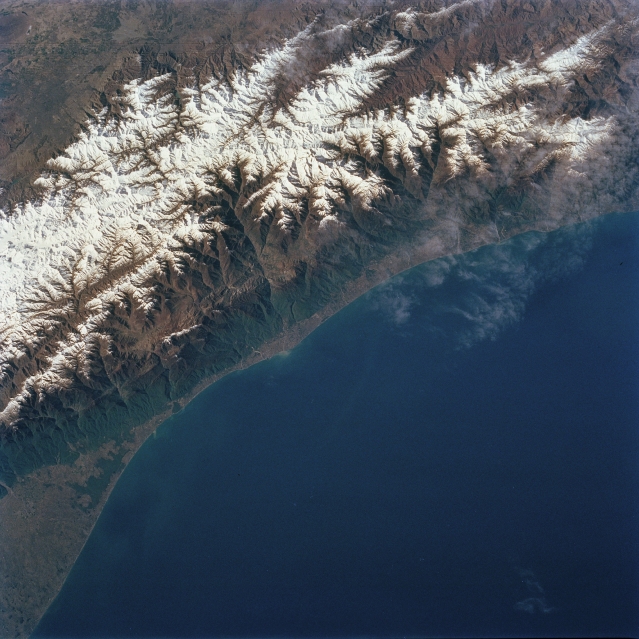 |
| STS056-079-025 Elburz Mountains, Iran April 1993 The western half of the Elburz Mountains, located in northern Iran along the south shore of the Caspian Sea, is visible in this southwest view. These snow-capped mountains are the northern limit of the Iranian Plateau. While the average elevation of the Elburz is 9000 feet (2743 meters), many of the higher peaks exceed 13000 feet (3962 meters) above sea level. Many of the higher elevations have permanent snowfields on them throughout the year. The mountains are a major climate barrier between the arid Iranian Plateau (south) and the moist (receives significant amounts of rain and snow) north facing slopes. Dense forests are visible on the north-facing slope that lead down to the narrow coastal plain. The Chalus River and several of its tributary streams has eroded a sizeable area of the mountain, thereby creating an impressive-looking, deep gorge (north-south aligned feature, slightly left of center). |
| Images: | All Available Images Low-Resolution 331k |
|
| Mission: | STS056 |
|
| Roll - Frame: | 79 - 25 |
|
| Geographical Name: | IRAN |
|
| Features: | ELBURZ MTS.,CASPIAN COAST |
|
| Center Lat x Lon: | 36.5N x 51.5E |
|
| Film Exposure: | N | N=Normal exposure, U=Under exposed, O=Over exposed, F=out of Focus |
| Percentage of Cloud Cover-CLDP: | 10 |
|
| Camera:: | HB |
|
| Camera Tilt: | 22 | LO=Low Oblique, HO=High Oblique, NV=Near Vertical |
| Camera Focal Length: | 100 |
|
| Nadir to Photo Center Direction: | S | The direction from the nadir to the center point, N=North, S=South, E=East, W=West |
| Stereo?: | N | Y=Yes there is an adjacent picture of the same area, N=No there isn't |
| Orbit Number: | 32 |
|
| Date: | 19930410 | YYYYMMDD |
| Time: | 044100 | GMT HHMMSS |
| Nadir Lat: | 37.6N |
Latitude of suborbital point of spacecraft |
| Nadir Lon: | 51.3E |
Longitude of suborbital point of spacecraft |
| Sun Azimuth: | 103 | Clockwise angle in degrees from north to the sun measured at the nadir point |
| Space Craft Altitude: | 163 | nautical miles |
| Sun Elevation: | 29 | Angle in degrees between the horizon and the sun, measured at the nadir point |
| Land Views: | MOUNTAIN, FOREST |
|
| Water Views: | SEA, RIVER |
|
| Atmosphere Views: | |
|
| Man Made Views: | |
|
| City Views: | |
|
Photo is not associated with any sequences | ||
| NASA Home Page |
JSC Home Page |
JSC Digital Image Collection |
Earth Science & Remote Sensing |
|
This service is provided by the International Space Station program and the JSC Earth Science & Remote Sensing Unit, ARES Division, Exploration Integration Science Directorate.

|