Geographic Region: MADEIRA ISLANDS
Feature: MADIERA ISLAND
|
Geographic Region: MADEIRA ISLANDS Feature: MADIERA ISLAND |
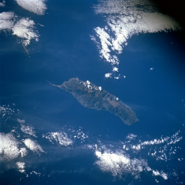 |
| STS056-078-091 Madeira Island, Portugal April 1993 Located in the Atlantic Ocean 350 miles (565 km) off the west coast of Morocco, Madeira Island can be seen in this southeast-looking view. Madeira Island is 34 miles (55 km) long and 12 miles (19 km) wide. The island has deep ravines and rugged mountains, with the highest point being Ruivo Peak near the center of the island at 6106 feet (1862 meters). The north coast of the island is particularly steep and very wild. The island produces wine, sugar, bananas, tropical fruits, and potatoes. Fishing, handicrafts, and tourism are other industries. Funchal, located on the southeast coast, is the main city on the island. |
| Images: | All Available Images Low-Resolution 291k |
|
| Mission: | STS056 |
|
| Roll - Frame: | 78 - 91 |
|
| Geographical Name: | MADEIRA ISLANDS |
|
| Features: | MADIERA ISLAND |
|
| Center Lat x Lon: | 32.5N x 17W |
|
| Film Exposure: | N | N=Normal exposure, U=Under exposed, O=Over exposed, F=out of Focus |
| Percentage of Cloud Cover-CLDP: | 30 |
|
| Camera:: | HB |
|
| Camera Tilt: | 53 | LO=Low Oblique, HO=High Oblique, NV=Near Vertical |
| Camera Focal Length: | 250 |
|
| Nadir to Photo Center Direction: | S | The direction from the nadir to the center point, N=North, S=South, E=East, W=West |
| Stereo?: | N | Y=Yes there is an adjacent picture of the same area, N=No there isn't |
| Orbit Number: | 35 |
|
| Date: | 19930410 | YYYYMMDD |
| Time: | 091234 | GMT HHMMSS |
| Nadir Lat: | 35.8N |
Latitude of suborbital point of spacecraft |
| Nadir Lon: | 15.6W |
Longitude of suborbital point of spacecraft |
| Sun Azimuth: | 103 | Clockwise angle in degrees from north to the sun measured at the nadir point |
| Space Craft Altitude: | 162 | nautical miles |
| Sun Elevation: | 31 | Angle in degrees between the horizon and the sun, measured at the nadir point |
| Land Views: | ISLAND, MOUNTAIN |
|
| Water Views: | OCEAN |
|
| Atmosphere Views: | |
|
| Man Made Views: | |
|
| City Views: | |
|
Photo is not associated with any sequences | ||
| NASA Home Page |
JSC Home Page |
JSC Digital Image Collection |
Earth Science & Remote Sensing |
|
This service is provided by the International Space Station program and the JSC Earth Science & Remote Sensing Unit, ARES Division, Exploration Integration Science Directorate.

|