
Geographic Region: CHINA
Feature: KARAKORAM RA,GLACIERS
|
Geographic Region: CHINA Feature: KARAKORAM RA,GLACIERS |
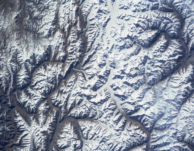 |
| STS056-152-038 Karakorum Mountains (K2), China April 1993 K2 (Mount Goodwin-Austin), the world's second tallest mountain peak (28250 feet - 8611 meters above sea level), is discernible as a small concentration of white slightly left of center. Located on the Pakistan (south) and China (north) border, K2 was not successfully climbed until 1954. In addition to this isolated peak, several other peaks in this scene exceed 23000 feet (7010 meters) above sea level. Several sizable glaciers are visible (linear, whitish-looking features), mainly on the Pakistan side of the border. The glaciated river valleys (dark linear features) drain northward towards the interior in the top half of the image, while the glaciated valleys in the southern half of the image are tributaries of the Indus River Basin. STS56-152-033 has a small area along its southeastern corner that provides some overlap with this image (upper left). |
| Images: | All Available Images Low-Resolution 352k |
|
| Mission: | STS056 |
|
| Roll - Frame: | 152 - 38 |
|
| Geographical Name: | CHINA |
|
| Features: | KARAKORAM RA,GLACIERS |
|
| Center Lat x Lon: | 36.0N x 76.5E |
|
| Film Exposure: | N | N=Normal exposure, U=Under exposed, O=Over exposed, F=out of Focus |
| Percentage of Cloud Cover-CLDP: | 0 |
|
| Camera:: | LH |
|
| Camera Tilt: | NV | LO=Low Oblique, HO=High Oblique, NV=Near Vertical |
| Camera Focal Length: | 250 |
|
| Nadir to Photo Center Direction: | The direction from the nadir to the center point, N=North, S=South, E=East, W=West |
|
| Stereo?: | Y | Y=Yes there is an adjacent picture of the same area, N=No there isn't |
| Orbit Number: | |
|
| Date: | 199304__ | YYYYMMDD |
| Time: | GMT HHMMSS |
|
| Nadir Lat: | N |
Latitude of suborbital point of spacecraft |
| Nadir Lon: | E |
Longitude of suborbital point of spacecraft |
| Sun Azimuth: | Clockwise angle in degrees from north to the sun measured at the nadir point |
|
| Space Craft Altitude: | nautical miles |
|
| Sun Elevation: | Angle in degrees between the horizon and the sun, measured at the nadir point |
|
| Land Views: | MOUNTAIN, VALLEY, FAULT, GLACIER |
|
| Water Views: | |
|
| Atmosphere Views: | |
|
| Man Made Views: | |
|
| City Views: | |
|
Photo is not associated with any sequences | ||
| NASA Home Page |
JSC Home Page |
JSC Digital Image Collection |
Earth Science & Remote Sensing |
|
This service is provided by the International Space Station program and the JSC Earth Science & Remote Sensing Unit, ARES Division, Exploration Integration Science Directorate.

|