Geographic Region: AUSTRALIA-T
Feature: EDDYSTONE POINT
|
Geographic Region: AUSTRALIA-T Feature: EDDYSTONE POINT |
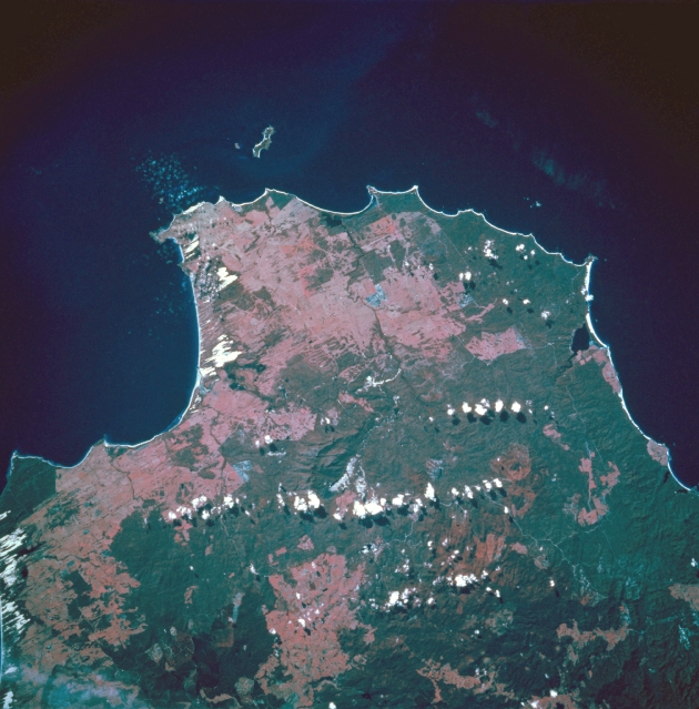 |
| STS056-110-080 Eddystone Point, Tasmania, Australia April 1993 The northeastern tip of Tasmania is observed in this northeasterly view that extends from Waterhouse Point in the northwest to the Bay of Fires along the east coast. Key features in this color infrared image include Eddystone Point (small peninsula that juts eastward into the Tasman Sea) and Ringarooma Bay which is located on the north coast of Tasmania and faces the Banks Strait. The white-looking areas along the coastline are sandy beaches and dunes further inland. A few cumulus clouds have formed primarily over the densely vegetated, forested lands (darker, more uniform-looking patterns). The pinkish colored landscape are areas where the forests have been cut down. This color infrared image presents the green range land and some cultivated fields as a pink signature. |
| Images: | All Available Images Low-Resolution 319k |
|
| Mission: | STS056 |
|
| Roll - Frame: | 110 - 80 |
|
| Geographical Name: | AUSTRALIA-T |
|
| Features: | EDDYSTONE POINT |
|
| Center Lat x Lon: | 41S x 148.0E |
|
| Film Exposure: | N | N=Normal exposure, U=Under exposed, O=Over exposed, F=out of Focus |
| Percentage of Cloud Cover-CLDP: | 5 |
|
| Camera:: | HB |
|
| Camera Tilt: | 16 | LO=Low Oblique, HO=High Oblique, NV=Near Vertical |
| Camera Focal Length: | 250 |
|
| Nadir to Photo Center Direction: | SE | The direction from the nadir to the center point, N=North, S=South, E=East, W=West |
| Stereo?: | N | Y=Yes there is an adjacent picture of the same area, N=No there isn't |
| Orbit Number: | 46 |
|
| Date: | 19930411 | YYYYMMDD |
| Time: | 021045 | GMT HHMMSS |
| Nadir Lat: | 40.6S |
Latitude of suborbital point of spacecraft |
| Nadir Lon: | 147.3E |
Longitude of suborbital point of spacecraft |
| Sun Azimuth: | 0 | Clockwise angle in degrees from north to the sun measured at the nadir point |
| Space Craft Altitude: | 166 | nautical miles |
| Sun Elevation: | 41 | Angle in degrees between the horizon and the sun, measured at the nadir point |
| Land Views: | PENINSULA |
|
| Water Views: | BAY |
|
| Atmosphere Views: | |
|
| Man Made Views: | |
|
| City Views: | |
|
Photo is not associated with any sequences | ||
| NASA Home Page |
JSC Home Page |
JSC Digital Image Collection |
Earth Science & Remote Sensing |
|
This service is provided by the International Space Station program and the JSC Earth Science & Remote Sensing Unit, ARES Division, Exploration Integration Science Directorate.

|