Geographic Region: ARGENTINA
Feature: SALT FLATS, AGRICULTURE, SMOKE
|
Geographic Region: ARGENTINA Feature: SALT FLATS, AGRICULTURE, SMOKE |
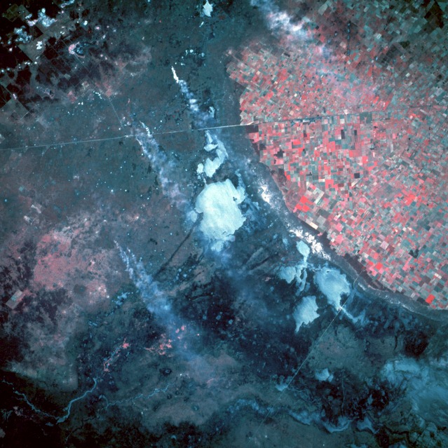 |
| STS056-109-080 Agricultural Area, North-Central Argentina April 1993 The color infrared film accurately delineates the intensively productive cultivated farmland (red colors) from the unproductive, poorly drained land in this near-vertical photograph taken near the small rural town of Ceres in north-central Argentina. The hundreds of field patterns show a well-established agricultural infrastructure. The darker areas west and northwest of the cultivated fields are part of a large interior drainage system that crosses broad alluvial fans that stretch eastward with gradually decreasing slopes. The whitish areas are dry lakebeds (salt flats) where the evaporation rate of surface water has exceeded the water recharge rate. Several south-trending smoke plumes probably originate on small parcels of land that are being cleared for agricultural use. The thin northwest-southeast line is a combined railroad and highway right-of-way. This area is part of the Chaco region of Argentina, a great expanse of lowland plain with deciduous scrub woodland interspersed with patches of savanna and poorly drained soils. STS-56 color infrared Earth observation taken aboard Discovery, Orbiter Vehicle (OV) 103, shows the agricultural frontier (rectangular field patterns) impinging on the natural grasslands (pampas) of northern Argentina. Note the sharp delineation between the upland agricultural areas (red and pink rectangles), and the lowland semi-arid grasslands or pampas (shown in violet and purple). In addition, several large smoke plumes associated with biomass burning are visible. These smoke plumes and their burn point sources are considered to be evident of extended agricultural preparations in the lowland pampas. |
| Images: | All Available Images Low-Resolution 151k |
|
| Mission: | STS056 |
|
| Roll - Frame: | 109 - 80 |
|
| Geographical Name: | ARGENTINA |
|
| Features: | SALT FLATS, AGRICULTURE, SMOKE |
|
| Center Lat x Lon: | N x E |
|
| Film Exposure: | N | N=Normal exposure, U=Under exposed, O=Over exposed, F=out of Focus |
| Percentage of Cloud Cover-CLDP: | 0 |
|
| Camera:: | HB |
|
| Camera Tilt: | LO | LO=Low Oblique, HO=High Oblique, NV=Near Vertical |
| Camera Focal Length: | 250 |
|
| Nadir to Photo Center Direction: | The direction from the nadir to the center point, N=North, S=South, E=East, W=West |
|
| Stereo?: | N | Y=Yes there is an adjacent picture of the same area, N=No there isn't |
| Orbit Number: | 39 |
|
| Date: | 19930410 | YYYYMMDD |
| Time: | 153427 | GMT HHMMSS |
| Nadir Lat: | 30.3S |
Latitude of suborbital point of spacecraft |
| Nadir Lon: | 62.5W |
Longitude of suborbital point of spacecraft |
| Sun Azimuth: | 14 | Clockwise angle in degrees from north to the sun measured at the nadir point |
| Space Craft Altitude: | 164 | nautical miles |
| Sun Elevation: | 51 | Angle in degrees between the horizon and the sun, measured at the nadir point |
| Land Views: | PLAIN, SALAR |
|
| Water Views: | SWAMP, RIVER |
|
| Atmosphere Views: | SMOKE |
|
| Man Made Views: | AGRICULTURE |
|
| City Views: | |
|
Photo is not associated with any sequences | ||
| NASA Home Page |
JSC Home Page |
JSC Digital Image Collection |
Earth Science & Remote Sensing |
|
This service is provided by the International Space Station program and the JSC Earth Science & Remote Sensing Unit, ARES Division, Exploration Integration Science Directorate.

|