Geographic Region: USA-TEXAS
Feature: GALVESTON BAY, HOUSTON
|
Geographic Region: USA-TEXAS Feature: GALVESTON BAY, HOUSTON |
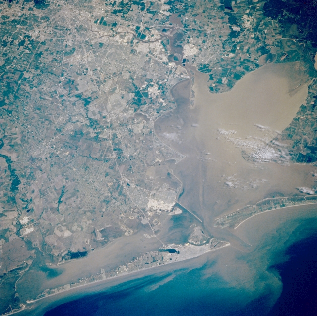 |
| STS055-071-040 Houston and Galveston, Texas, U.S.A. May 1993 Apparent in this photograph is the coalescing of the corridor between Houston, the country's fourth largest city, and Galveston Island, 45 miles (72 kilometers) southeast of downtown Houston, resulting in shrinking availability of rural, agricultural lands. The Texas City Dike [5 miles (8 kilometers) long], originally constructed as a protective breakwater for the Texas City Ship Channel and port, juts southeastward toward the mouth of Galveston Bay, whose entrance is visible between the eastern end of Galveston Island and the western tip of Bolivar Peninsula. Discernible are highly reflective concentrations of oil refineries and petrochemical plants in Texas City and along the Houston Ship Channel; Interstate Highway 45, the major artery that connects Houston and Galveston Island; and other highway systems. |
| Images: | All Available Images Low-Resolution 367k |
|
| Mission: | STS055 |
|
| Roll - Frame: | 71 - 40 |
|
| Geographical Name: | USA-TEXAS |
|
| Features: | GALVESTON BAY, HOUSTON |
|
| Center Lat x Lon: | 29.5N x 95W |
|
| Film Exposure: | N | N=Normal exposure, U=Under exposed, O=Over exposed, F=out of Focus |
| Percentage of Cloud Cover-CLDP: | 5 |
|
| Camera:: | HB |
|
| Camera Tilt: | 30 | LO=Low Oblique, HO=High Oblique, NV=Near Vertical |
| Camera Focal Length: | 250 |
|
| Nadir to Photo Center Direction: | NW | The direction from the nadir to the center point, N=North, S=South, E=East, W=West |
| Stereo?: | Y | Y=Yes there is an adjacent picture of the same area, N=No there isn't |
| Orbit Number: | 2 |
|
| Date: | 19930426 | YYYYMMDD |
| Time: | 162723 | GMT HHMMSS |
| Nadir Lat: | 28.3N |
Latitude of suborbital point of spacecraft |
| Nadir Lon: | 94W |
Longitude of suborbital point of spacecraft |
| Sun Azimuth: | 115 | Clockwise angle in degrees from north to the sun measured at the nadir point |
| Space Craft Altitude: | 163 | nautical miles |
| Sun Elevation: | 61 | Angle in degrees between the horizon and the sun, measured at the nadir point |
| Land Views: | COAST, PLAIN, ISLAND, PENINSULA |
|
| Water Views: | BAY, CHANNEL, GULF |
|
| Atmosphere Views: | |
|
| Man Made Views: | HIGHWAY, URBAN AREA |
|
| City Views: | |
|
Photo is not associated with any sequences | ||
| NASA Home Page |
JSC Home Page |
JSC Digital Image Collection |
Earth Science & Remote Sensing |
|
This service is provided by the International Space Station program and the JSC Earth Science & Remote Sensing Unit, ARES Division, Exploration Integration Science Directorate.

|