Geographic Region: RUSSIAN FEDERATION
Feature: KAMCHATKA PEN., SNOW
|
Geographic Region: RUSSIAN FEDERATION Feature: KAMCHATKA PEN., SNOW |
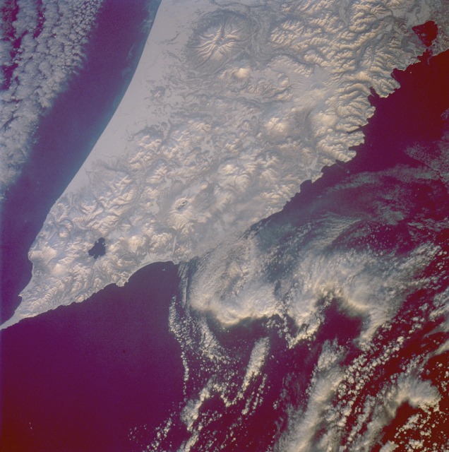 |
| STS053-96-83 Volcanoes, Kamchatka Peninsula, Russia December 1992 No volcanoes appear to be active at the time this photograph was taken of the southern tip of snow-covered Kamchatka Peninsula. The snow-covered terrain actually increases the clarity of the volcanic landscape for the viewer. Except for the plains along the west coast of Kamchatka, a variety of volcanic landforms (stratovolcanoes, shield volcanoes, complex volcanoes, cinder cones, and calderas) covers almost the entire Kamchatka Peninsula. Three prominent volcanic features appear in the photograph--the massive but severely eroded volcano along the northwest side of the photograph, approximately 30 miles (50 kilometers) in diameter at its base; the lake near the southern end of Kamchatka (Kurile Lake), which is actually a water-filled caldera from an older volcano (Pauzhetka Volcano); and a large caldera (Ksudach Volcano) northeast of Lake Kurile that reveals just a small area of open water. The peaks of several of the taller stratovolcanoes in this photograph exceed 6000 feet (1800 meters) above sea level. The Kamchatka Peninsula is bounded by the Bering Sea on the east and the Sea of Okhotsk on the west. |
| Images: | All Available Images Low-Resolution 125k |
|
| Mission: | STS053 |
|
| Roll - Frame: | 96 - 83 |
|
| Geographical Name: | RUSSIAN FEDERATION |
|
| Features: | KAMCHATKA PEN., SNOW |
|
| Center Lat x Lon: | 52.0N x 157.5E |
|
| Film Exposure: | N | N=Normal exposure, U=Under exposed, O=Over exposed, F=out of Focus |
| Percentage of Cloud Cover-CLDP: | 30 |
|
| Camera:: | HB |
|
| Camera Tilt: | 47 | LO=Low Oblique, HO=High Oblique, NV=Near Vertical |
| Camera Focal Length: | 250 |
|
| Nadir to Photo Center Direction: | W | The direction from the nadir to the center point, N=North, S=South, E=East, W=West |
| Stereo?: | Y | Y=Yes there is an adjacent picture of the same area, N=No there isn't |
| Orbit Number: | 54 |
|
| Date: | 19921205 | YYYYMMDD |
| Time: | 221918 | GMT HHMMSS |
| Nadir Lat: | 50.9N |
Latitude of suborbital point of spacecraft |
| Nadir Lon: | 160.5E |
Longitude of suborbital point of spacecraft |
| Sun Azimuth: | 141 | Clockwise angle in degrees from north to the sun measured at the nadir point |
| Space Craft Altitude: | 182 | nautical miles |
| Sun Elevation: | 8 | Angle in degrees between the horizon and the sun, measured at the nadir point |
| Land Views: | VOLCANO, CRATER |
|
| Water Views: | |
|
| Atmosphere Views: | |
|
| Man Made Views: | |
|
| City Views: | |
|
Photo is not associated with any sequences | ||
| NASA Home Page |
JSC Home Page |
JSC Digital Image Collection |
Earth Science & Remote Sensing |
|
This service is provided by the International Space Station program and the JSC Earth Science & Remote Sensing Unit, ARES Division, Exploration Integration Science Directorate.

|