Geographic Region: CHAD
Feature: LAKE CHAD
|
Geographic Region: CHAD Feature: LAKE CHAD |
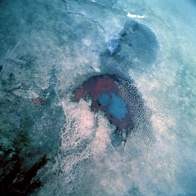 |
| STS052-099-009 Lake Chad, Chad October 1992 The four north-central African countries of Chad, Niger, Nigeria, and Cameroon share a common feature--borders that extend into Lake Chad. Millions of years ago, Lake Chad encompassed more than 100 000 square miles (260 000 square kilometers) in central Africa. This low-oblique, color infrared photograph shows approximately 965 square miles (2500 square kilometers) of open water in the south basin (blue). Since the mid-1970s, only the south basin has had open water; many sand dunes cover the former lake floor, forming inlets into the remaining area of open water. Climatic changes, dynamic shifts in the Earth's crust, and evaporation interacted to reduce the lake's surface area. The Chari River, with its substantial delta on the southern side of the lake, supplies approximately 95 percent of the lake's water. The Komadougou Yobe River of Niger and its ephemeral tributary streams enter the northern basin of Lake Chad along the western shoreline, but no large areas of vegetation exist in the north basin. In contrast, the south basin shows a large area of vigorous vegetation (reddish and darker areas). (Refer to STS-061-075-022, AS7-008-1932, and STS-026-043-098 to further document the changes occurring in Lake Chad.) |
| Images: | All Available Images Low-Resolution 151k |
|
| Mission: | STS052 |
|
| Roll - Frame: | 99 - 9 |
|
| Geographical Name: | CHAD |
|
| Features: | LAKE CHAD |
|
| Center Lat x Lon: | 13.0N x 14.0E |
|
| Film Exposure: | N | N=Normal exposure, U=Under exposed, O=Over exposed, F=out of Focus |
| Percentage of Cloud Cover-CLDP: | 0 |
|
| Camera:: | HB |
|
| Camera Tilt: | 29 | LO=Low Oblique, HO=High Oblique, NV=Near Vertical |
| Camera Focal Length: | 100 |
|
| Nadir to Photo Center Direction: | NW | The direction from the nadir to the center point, N=North, S=South, E=East, W=West |
| Stereo?: | Y | Y=Yes there is an adjacent picture of the same area, N=No there isn't |
| Orbit Number: | 62 |
|
| Date: | 19921026 | YYYYMMDD |
| Time: | 131210 | GMT HHMMSS |
| Nadir Lat: | 12.2N |
Latitude of suborbital point of spacecraft |
| Nadir Lon: | 15.2E |
Longitude of suborbital point of spacecraft |
| Sun Azimuth: | 237 | Clockwise angle in degrees from north to the sun measured at the nadir point |
| Space Craft Altitude: | 157 | nautical miles |
| Sun Elevation: | 45 | Angle in degrees between the horizon and the sun, measured at the nadir point |
| Land Views: | DESERT, PLAIN, DUNE |
|
| Water Views: | RIVER, DELTA, LAKE, SWAMP |
|
| Atmosphere Views: | |
|
| Man Made Views: | |
|
| City Views: | |
|
Associated Photos in Sequence:  Photo #: AS07-8-1932 Photo #: AS07-8-1932Description: AFRICA, LAKE CHAD-1968--LAKE LEVELS BEFORE BEGINNING OF DROUGHT, 1970 Sequence ID: 3A  Photo #: STS052-99-9 ** Currently displayed photo ** Photo #: STS052-99-9 ** Currently displayed photo ** Description: AFRICA, LAKE CHAD-1992--LAKE LEVELS FROM DROUGHT THAT BEGAN IN 1970 Sequence ID: 3B  Photo #: STS052-80-66 Photo #: STS052-80-66Description: AFRICA, LAKE CHAD-1992--LAKE LEVELS FROM DROUGHT THAT BEGAN IN 1970 Sequence ID: 3C  Photo #: STS061-75-22 Photo #: STS061-75-22Description: AFRICA, LAKE CHAD-1993--LAKE LEVELS FROM DROUGHT THAT BEGAN IN 1970 Sequence ID: 3D  Photo #: STS061-75-23 Photo #: STS061-75-23Description: AFRICA, LAKE CHAD-1993--LAKE LEVELS FROM DROUGHT THAT BEGAN IN 1970 Sequence ID: 3E | ||
| NASA Home Page |
JSC Home Page |
JSC Digital Image Collection |
Earth Science & Remote Sensing |
|
This service is provided by the International Space Station program and the JSC Earth Science & Remote Sensing Unit, ARES Division, Exploration Integration Science Directorate.

|