Geographic Region: DOMINICAN REPUBLIC
Feature: BARAHONA, RINCON L, AGR.
|
Geographic Region: DOMINICAN REPUBLIC Feature: BARAHONA, RINCON L, AGR. |
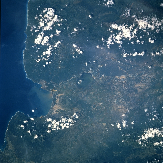 |
| STS051-072-086 Enriquillo Plain, Dominican Republic September 1993 This near-nadir view shows the eastern portion of a rift valley that extends 79 miles (127 km) from Port-au-Prince in Haiti (not visible on the image) to Neiba Bay (left center of the image) in the Dominican Republic. The rift valley, a former marine strait, is referred to as the Hoya de Enriquillo in the Dominican Republic and the Cul-de-Sac Depression in Haiti. This portion of the rift valley in the Dominican Republic is 12 miles (20 km) wide. Rincon Lake, a shallow salt lake, is discernible near the center of the image. Agriculture is prominent on the valley floor. The city of Barahona is discernible on the south shore of Neiba Bay near the left center of the view. Over the last decade or so, tourism has become a major industry in the region. The long runway of the Barahona Airport is also visible just to the southwest of the city. Scattered clouds cover the Baoruco Mountains to the south (upper portion of the image) of the Hoya de Enriquillo. |
| Images: | All Available Images Low-Resolution 359k |
|
| Mission: | STS051 |
|
| Roll - Frame: | 72 - 86 |
|
| Geographical Name: | DOMINICAN REPUBLIC |
|
| Features: | BARAHONA, RINCON L, AGR. |
|
| Center Lat x Lon: | 18.0N x 71.5W |
|
| Film Exposure: | N | N=Normal exposure, U=Under exposed, O=Over exposed, F=out of Focus |
| Percentage of Cloud Cover-CLDP: | 15 |
|
| Camera:: | HB |
|
| Camera Tilt: | 17 | LO=Low Oblique, HO=High Oblique, NV=Near Vertical |
| Camera Focal Length: | 250 |
|
| Nadir to Photo Center Direction: | W | The direction from the nadir to the center point, N=North, S=South, E=East, W=West |
| Stereo?: | Y | Y=Yes there is an adjacent picture of the same area, N=No there isn't |
| Orbit Number: | 34 |
|
| Date: | 19930914 | YYYYMMDD |
| Time: | 134117 | GMT HHMMSS |
| Nadir Lat: | 17.7N |
Latitude of suborbital point of spacecraft |
| Nadir Lon: | 70.7W |
Longitude of suborbital point of spacecraft |
| Sun Azimuth: | 103 | Clockwise angle in degrees from north to the sun measured at the nadir point |
| Space Craft Altitude: | 163 | nautical miles |
| Sun Elevation: | 44 | Angle in degrees between the horizon and the sun, measured at the nadir point |
| Land Views: | MOUNTAIN, PLAIN |
|
| Water Views: | LAKE, BAY |
|
| Atmosphere Views: | |
|
| Man Made Views: | AIRPORT |
|
| City Views: | |
|
Photo is not associated with any sequences | ||
| NASA Home Page |
JSC Home Page |
JSC Digital Image Collection |
Earth Science & Remote Sensing |
|
This service is provided by the International Space Station program and the JSC Earth Science & Remote Sensing Unit, ARES Division, Exploration Integration Science Directorate.

|